~ Essex & Suffolk ~ Sea Charts, Town Plans & Maps ~
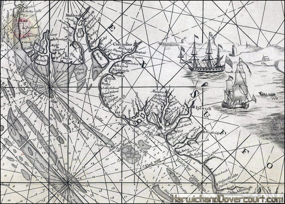
~ 1702 ~ Harwich, Woodbridge & Hamford Water H&D ~
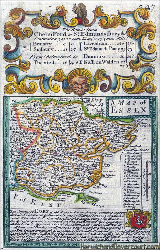
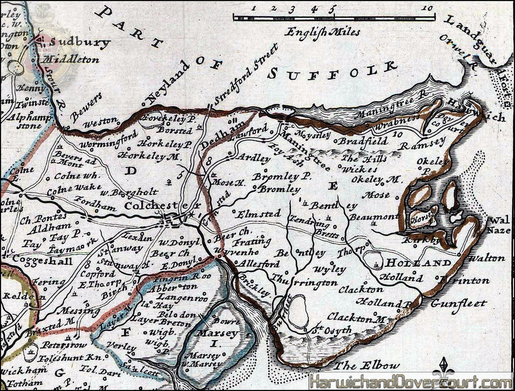
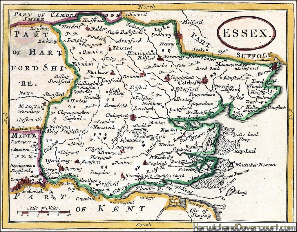
~ 1708 ~ Essex by Robert Morden H&D ~
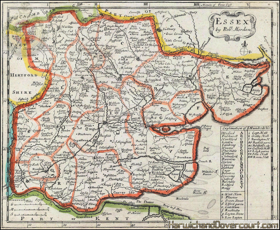
Striking and celebrated county map of Essex with inset plan of Colchester. Published by Bassett & Chiswell. Decorative illustrations, silk sea, heraldry of Essex Earls, and coins with busts of Roman Emporers adorn the map, with intricately engraved strapwork.
Skelton, R. A.: "County Atlases of the British Isles 1579-1703"
Skelton, R. A.: "County Atlases of the British Isles 1579-1703"
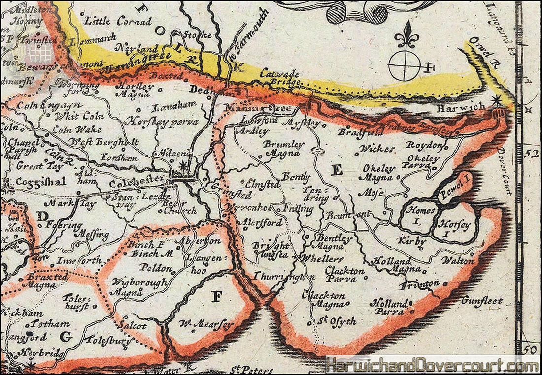
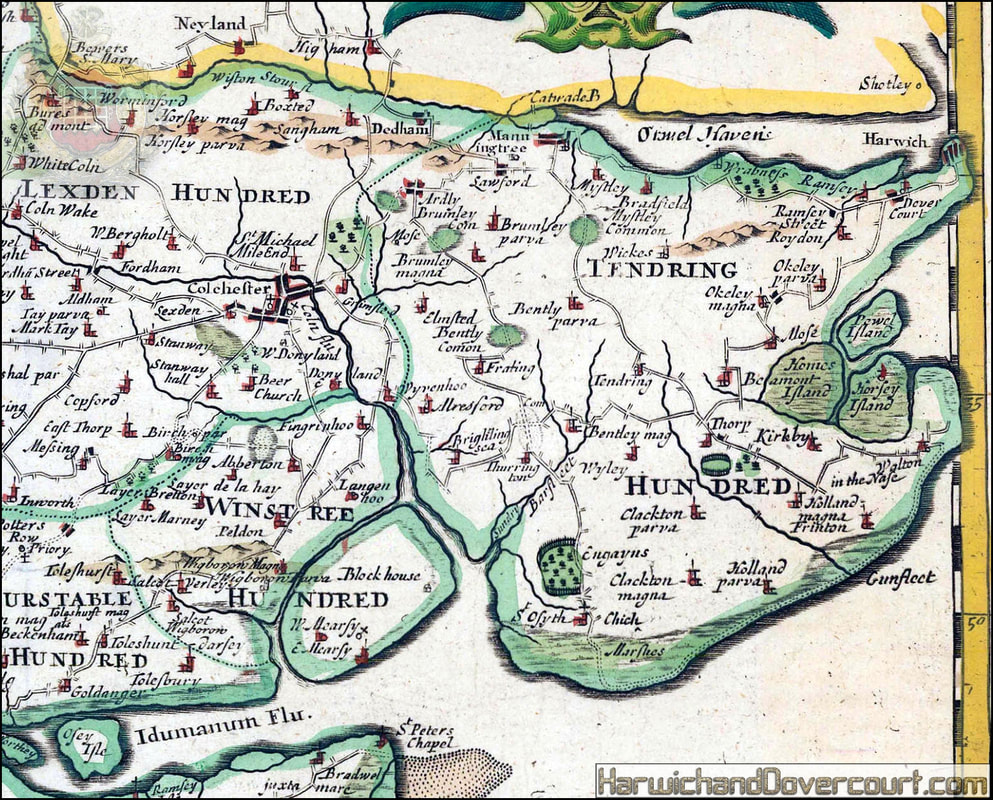
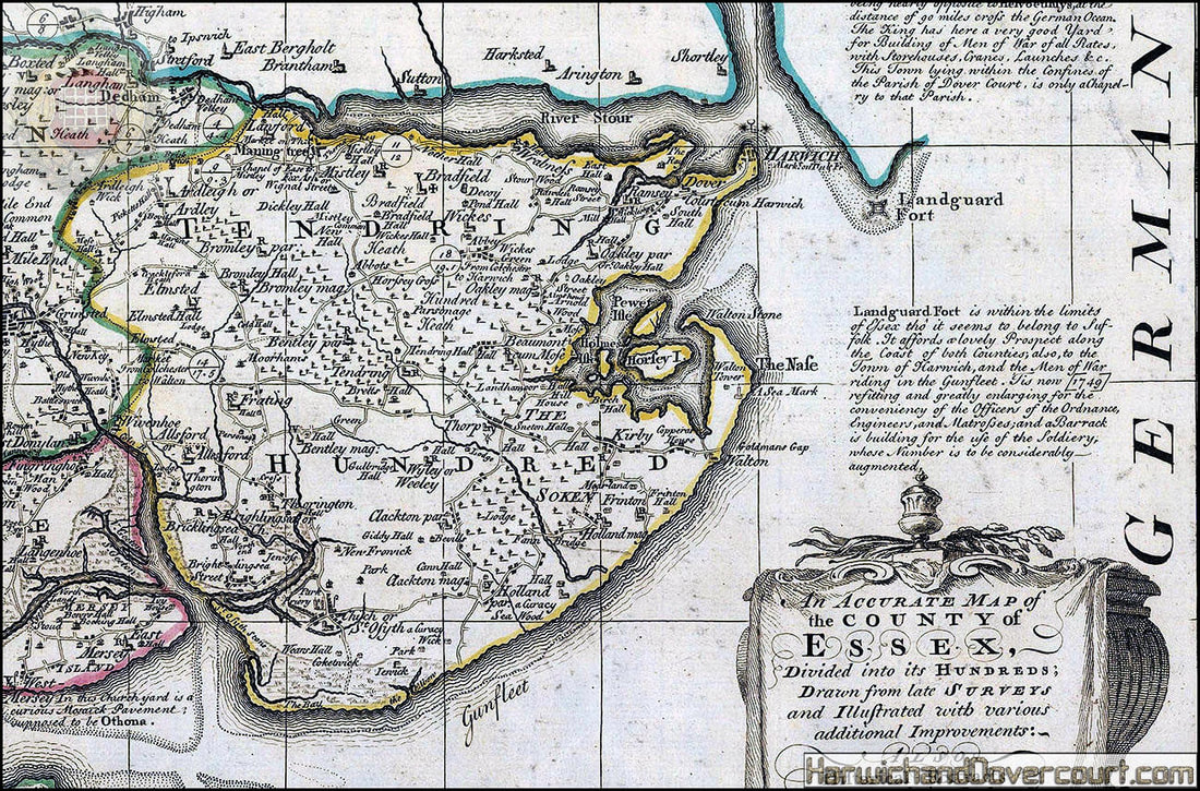
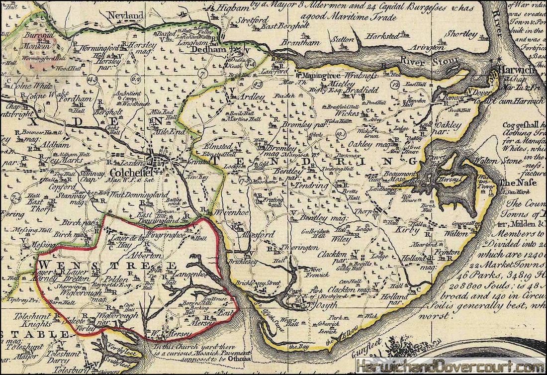
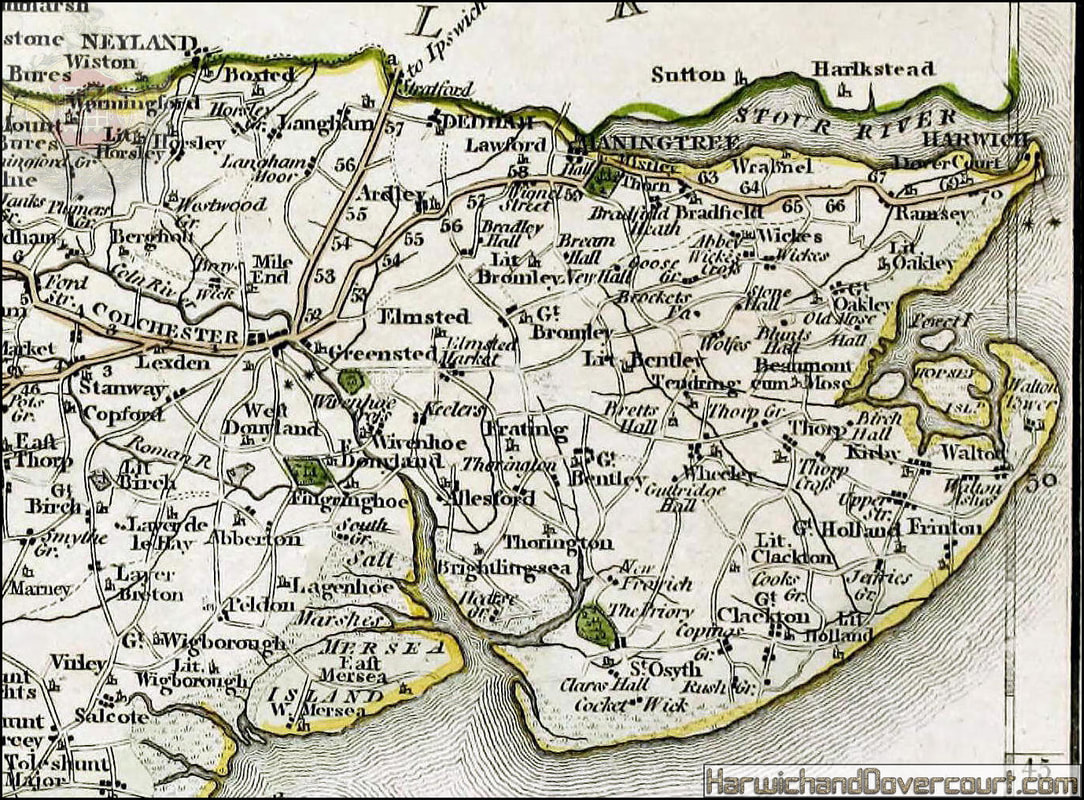
~ 1708 ~ Essex by Robert Morden H&D ~ Detailed Tendring Section ~
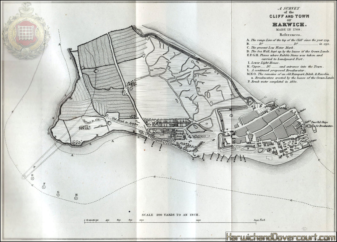
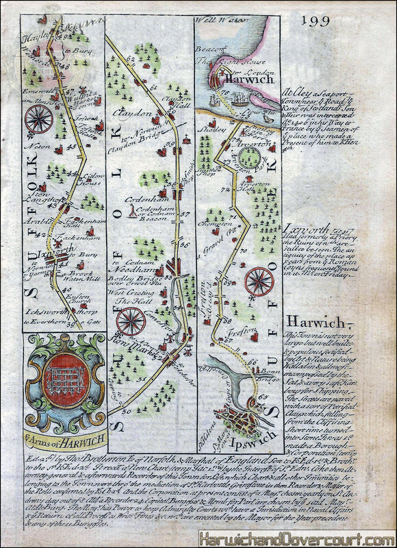
~ 1709 ~ Cliff and Town of Harwich, Essex H&D ~
~ 1715 ~ Johannes Kip Harwich, Essex H&D ~ Uncoloured Version ~
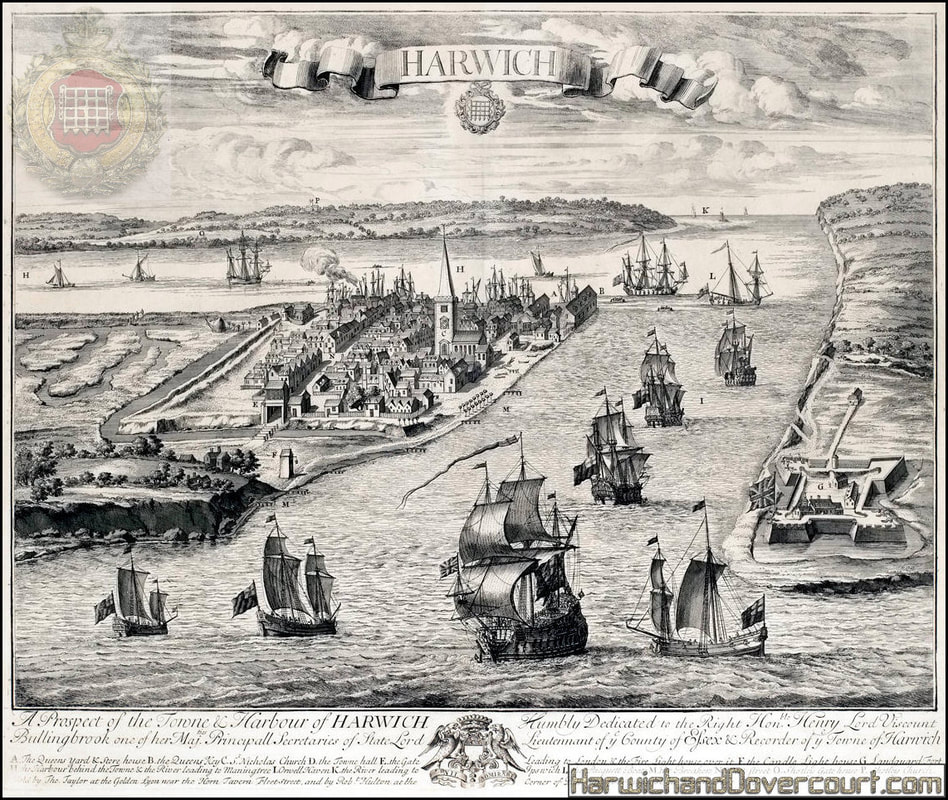
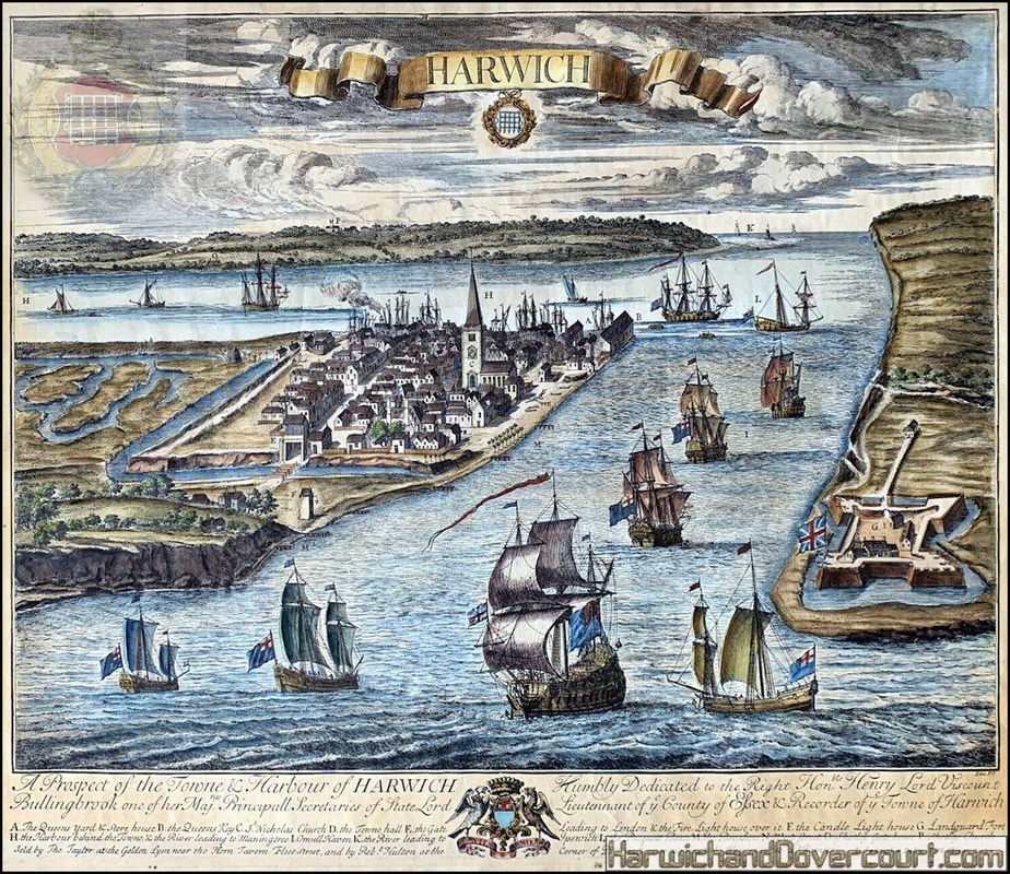
~ 1720 ~ A Prospect of the Town & Harbor of Harwich H&D ~ Coloured Version ~
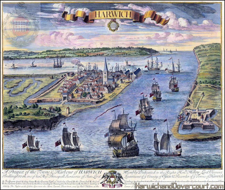
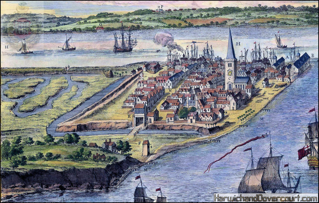
~ 1720 ~ A Prospect of the Town & Harbor of Harwich H&D ~ Detailed Version ~
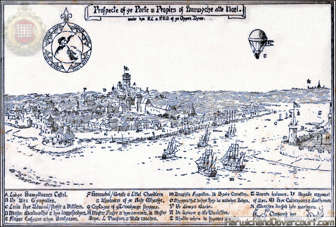
~ 1720 ~ A Prospect of the Town & Harbor of Harwich Noel H&D ~ Interesting Comments ~
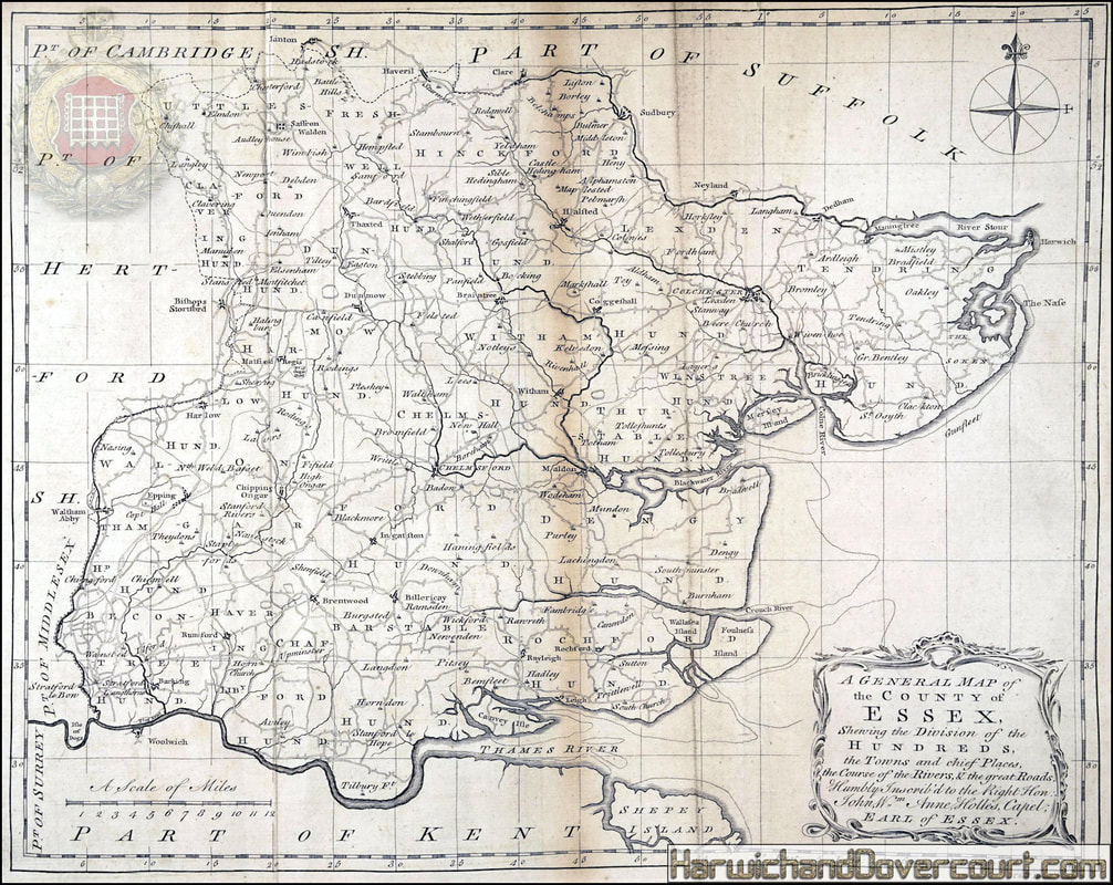
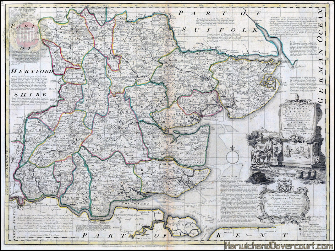
~ 1720 ~ Bowens Map of Essex H&D ~

~ 1720 ~ Captain Greenvile-Collins Sea Chart of East Anglia from the Thames to the Humber ~
Sea Chart of East Anglia from the Thames to the Humber
A splendid chart on two sheets (joined) of East Anglia from the mouth of the Thames to the mouth of the River Humber in Lincolnshire.
This map was originally issued by Captain Greenvile Collins in the Great Britain Coasting Pilot, the first major survey of the coasts of the United Kingdom made by an English hydrographer. The work was highly successful and issued in several new editions throughout the 18th century. This map is one of the early re-issues with only Collin's name on the title, on heavy paper and with the copper plate giving a sharp and crisp impression.
The map is orientated east to west and shows a detailed survey of the coastlines of Essex, Suffolk, Norfolk, and Lincolnshire. A large inset on the upper part of the map shows the Thames from London to the Buoy of the Nore. The Nore is a sandbank in the Thames Estuary and generally acknowledged as the point where the Thames meets the North Sea. The inset is orientated with south on top.
In the middle of the map there is a large cartouche depicting a maritime scene and bearing a dedication to the Master and Wardens of Trinity House; Collins himself had been made a Warden of the House and it was also their responsibility to care and maintain the highly important chain of navigation buoys along the Thames, including the Buoy of the Nore.
~ 1720 ~ Captain Greenvile Collins Sea Chart of East Anglia from the Thames to the Humber ~
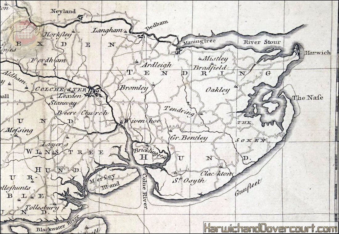
~ East Anglia ~ Detailed Section ~
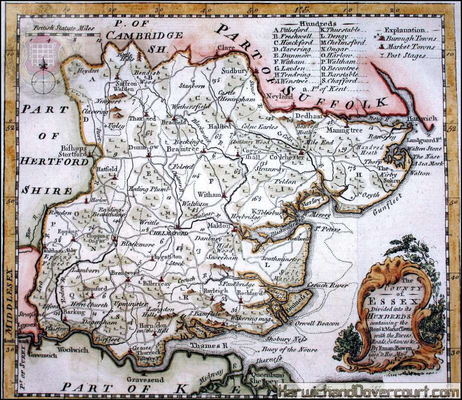
~ 1720 ~ Emanuel Bowen & John Owen A Map of Essex H&D ~
Essex. Decorative county map, with description and distances. Coloured.
~ 1719 ~ Owen Bowen Route to Harwich H&D ~
The Road from London to Harwich [London - Stratford - Romford - Brentwood - Ingatestone - Chelmsford - Witham - Kelvedon - Colchester - Manningtree - Harwich]
Antique copperplate road strip map
Cartographer : Thomas Gardner
Provenance: "A Pocket guide to the English Traveller", London:
Printed for J. Tonson at Shakespear's Head over-against Katherine-Street in the Strand, and J. Watts at the Printing-Office in Wild-Court near Lincoln's-Inn Fields
Antique copperplate road strip map
Cartographer : Thomas Gardner
Provenance: "A Pocket guide to the English Traveller", London:
Printed for J. Tonson at Shakespear's Head over-against Katherine-Street in the Strand, and J. Watts at the Printing-Office in Wild-Court near Lincoln's-Inn Fields
~ 1724 ~ Herman Moll Essex H&D ~
~ Herman Moll , 1724 ~ Essex ~
This charming county map is noted for its border illustrations. These include a pair of Roman coins and a pair of supposed British coins. The lower right corner also shows a miniature plan of William Boswell's unsuccessful attemtp to repair the Breach of the bank of the Thames at Dagenham. However, the most interesting vignettes on this map can be seen on the left border, which illustrates two Deneholes. These were mysterious tunnels made into chalk hills whose exact function is still debated. They were known to have been mentioned in prehistory as Pliny mentions them in his Histories. Despite their antiquity and speculation, it is still unknown if they were mines for chalk extraction, defensive measures or places for ritual.
This charming county map is noted for its border illustrations. These include a pair of Roman coins and a pair of supposed British coins. The lower right corner also shows a miniature plan of William Boswell's unsuccessful attemtp to repair the Breach of the bank of the Thames at Dagenham. However, the most interesting vignettes on this map can be seen on the left border, which illustrates two Deneholes. These were mysterious tunnels made into chalk hills whose exact function is still debated. They were known to have been mentioned in prehistory as Pliny mentions them in his Histories. Despite their antiquity and speculation, it is still unknown if they were mines for chalk extraction, defensive measures or places for ritual.
~ 1724 ~ Herman Moll Essex H&D ~ Detailed Tendring Section ~
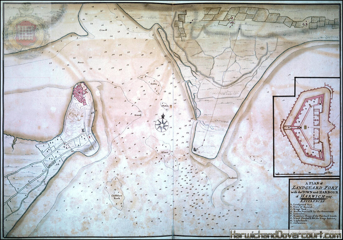
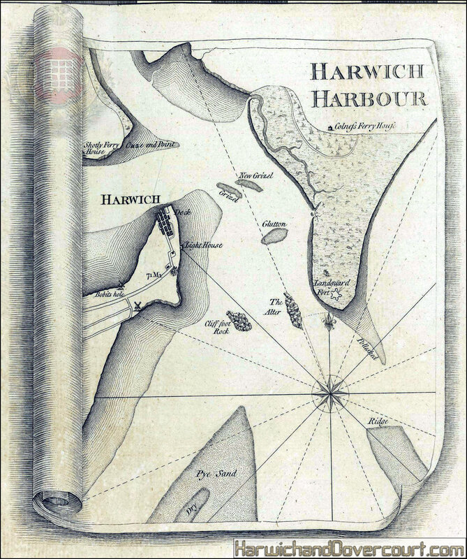
~ 1725 ~ Landguard Fort & Harwich Harbour H&D ~
~ 1742 ~ Essex N.E. from London Badeslade H&D ~

~ 1750 ~ A Prospect of the Towne & Harbour of Harwich H&D ~
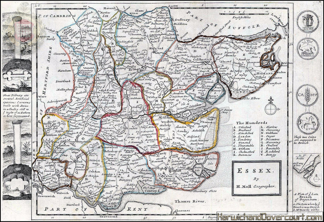
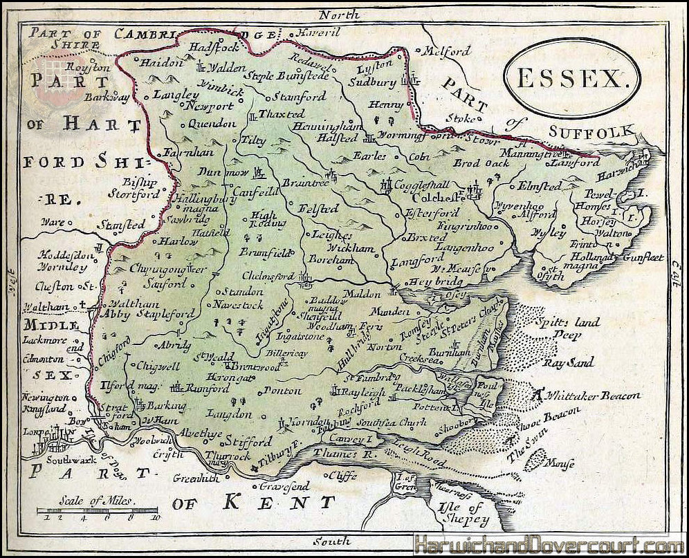
~1753 ~ Robert Morden Map of Essex H&D ~
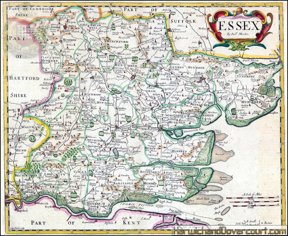
Essex.
Early county map with a decorative cartouche.
This 18th-century example of Morden's map was published to illustrate a 1753 edition of William Camden's "Britannia". Coloured.
Early county map with a decorative cartouche.
This 18th-century example of Morden's map was published to illustrate a 1753 edition of William Camden's "Britannia". Coloured.
~ 1753 ~ Robert Morden Map of Essex H&D ~ Detailed Tendring Section ~
~ 1759 ~ A General Map Of The County Of Essex by Thomas Bowen H&D ~
~ 1759 ~ A General Map Of The County Of Essex by Thomas Bowen H&D ~
~ Detailed Tendring Section ~
~ 1759 ~ Map of Essex by Bowen H&D ~
~ 1760 ~ Emanuel Bowen An Accurate Map of the county of Essex H&D ~
An Accurate Map of the County of Essex
Superb county map of Essex from Bowen's landmark survey of Georgian England.
The map features a decorative cartouche with an agricultural scene, and below a curious vignette depicting people being burnt a the stake in 1555 - this is a reference to the men and women executed for treason because of their religious beliefs during the English Reformation (between 1534-1680). Under the reign of Queen Mary I, around 300 protestants were condemned to death, earning her the nickname 'Bloody Mary'.
The margins of the map are filled with fascinating notes about the towns, industry, markets and nobility of the county. This county map is dedicated to Benjamin Mildmay, Earl Fitzwalter between 1728-1730.
Original hand-colour.
~ 1760 ~ Emanuel Bowen An Accurate Map of the county of Essex H&D ~
~ Detailed Tendring Section ~
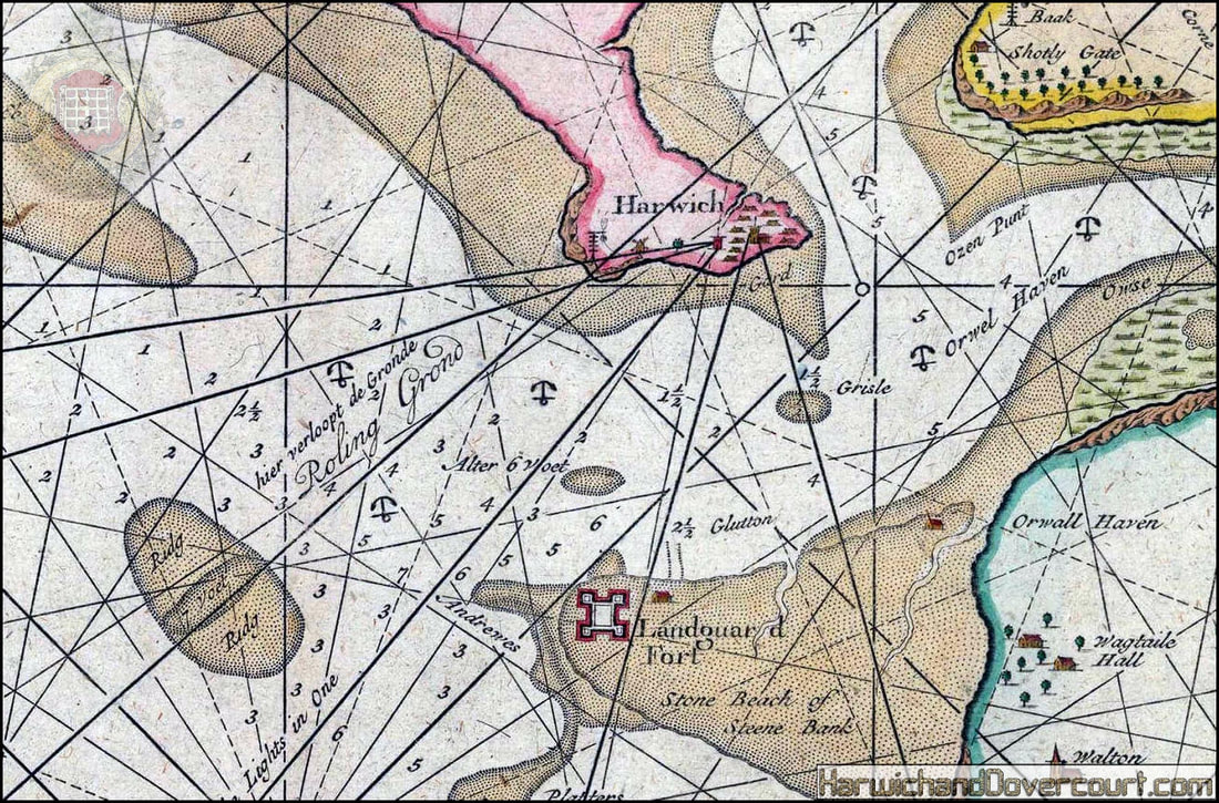
~ 1760 ~ Gerard Van Keulen-De-Reede-Van Covering ~
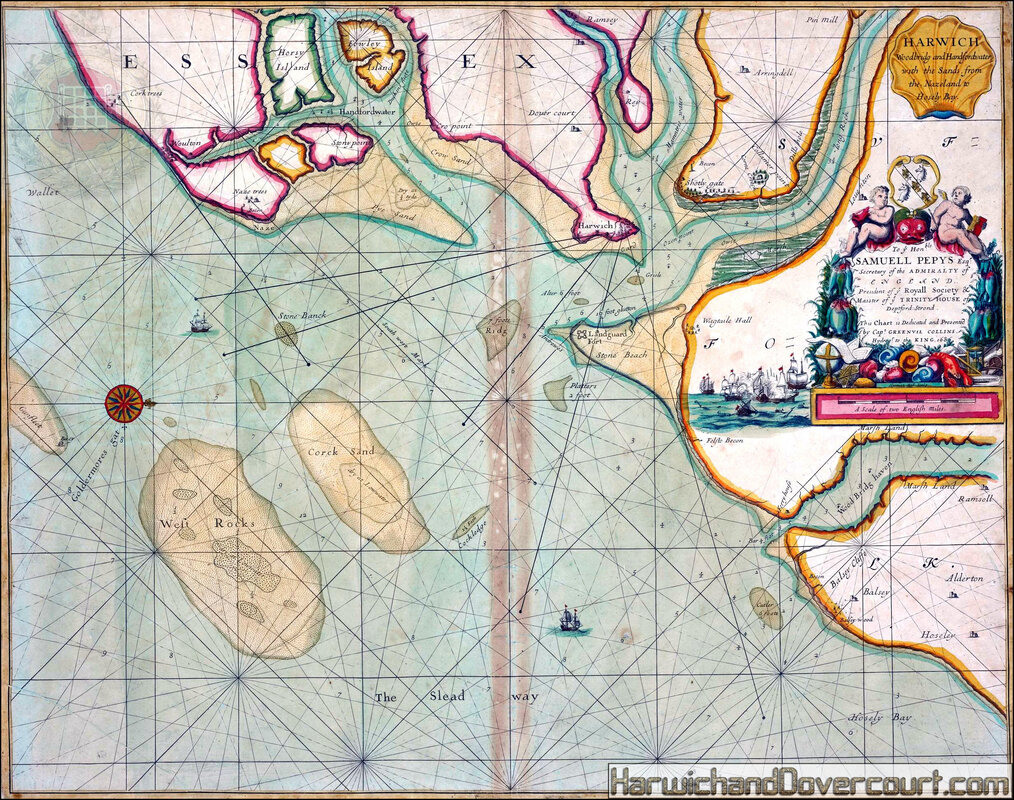
~ Harwich, Hamford Water & Woodbridge Haaven H&D ~

De Reede van Harwich, Handford - Water en Wood Bridg Haaven
Grand sea chart along the coastlines of Essex and Suffolk showing Harwich, Handford, Water on Wood, and Bridgehaven. Coloured.
•Harwich Woodbridge and Handfordwater with the sands from the Nazeland to Hosely Bay. To ye Honble Samuel Pepys Esq this chart is dedicated and presented by Capt Greenvil Collins Hydrog to the King 1686
London:, 1760. Size: 565 x 440 mm. Copper engraving. Later colour.
An attractive sea chart of Harwich and surrounding coastline, north to right of map, soundings, rhumb lines. Decorated dedicatory cartouche- to Samuel Pepys- with cherubs, fish and shells, and scale in English miles below, with a sketch of a sea battle to left of cartouche. Captain Greenvile Collins was an outstanding naval officer who became 'Hydrographer to the King' before the Coasting Pilot was published. The Coasting Pilot was the result of the first systematic survey of British coastal waters. It took eight years to complete. The charts are notable for both their accuracy and their charm. Published in the 'Great Britain Coasting Pilot'.
~ 1760 ~ Gerard Van Keulen-De-Reede-Van Covering ~
~ Harwich, Hamford Water & Woodbridge Haaven H&D ~ Detailed Harwich Harbour Section ~
~ 1764 ~ Jacques Nicolas-Bellin Essex, Kent the mouth of the Thames H&D ~
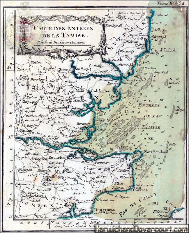
Essex, Kent & the Mouth of the Thames
Carte des Entrees de la Tamise
This small chart focuses on the coasts and sandbanks off south east England with the mouth of the Thames in its centre.
Jacques-Nicolas Bellin was one of the greatest 18th century map makers. He specialised in hydrography and was appointed to the French Hydrographic office at the young age of 18 in 1721. Twenty years later he was named the first “Ingenieur de la Marine” for the “Depot des Cartes et Plans de la Marine” as well as Hydrographer to Louis XV of France. Over a fifty year career, he published a multitude of important maps often from first hand sources provided by naval officers, merchants and government sources. His level of access was extraordinary. As well as publishing his own atlases, he was a contributor to many seminal French works on exploration, including Abbee Raynal’s “Histoire des Deux Indes”, Abbee Prevost’s “Histoire Generale des Voyages” and Pierre de Charlevoix’s “Histoire et Description Generale de la Nouvelle France”.
In 1762, Bellin decided to publish one of his most popular and accessible works: “Le Petit Atlas Maritime”. The work came out in 1764 in five volumes and proved extremely popular. Many of the maps were reduced versions which Bellin had either contributed or published previously. The five volumes usually contain between 575 and 590 maps with variations noted between individual examples. As the preparation took only two years, it is very likely that Bellin had a majority of these copper plates already available. The initial financial support for the atlas was from Etienne-Francois, Duc de Choiseul, a highly placed French politician who was credited for strengthening both the army and navy. Due to its accessibility, he perceived the ”Petit Atlas Maritime” as a method of publicising both the work of the “Depot de la Marine” and the Navy to the general public. Bellin includes a long dedication to Choiseul on the front of each volume.
For collectors today, the work presents one of the widest selection of extremely desirable smaller maps. They provide clear, concise and attractive geographical records of some of the most inaccessible and exotic areas of the world in the mid-18th century. Bellin was part of a group called “Les Philosophes”, the French counterpart to the pioneers of the English Age of Reason and his maps are a lasting legacy from the Age of French Enlightenment.
As with all of these small charts of the English coast, this map would have been a reduction of a large naval survey accessible to Bellin through the Depot de la Marine. As a traditional marine foe, the French Admiralty would have an archive of coastal survey
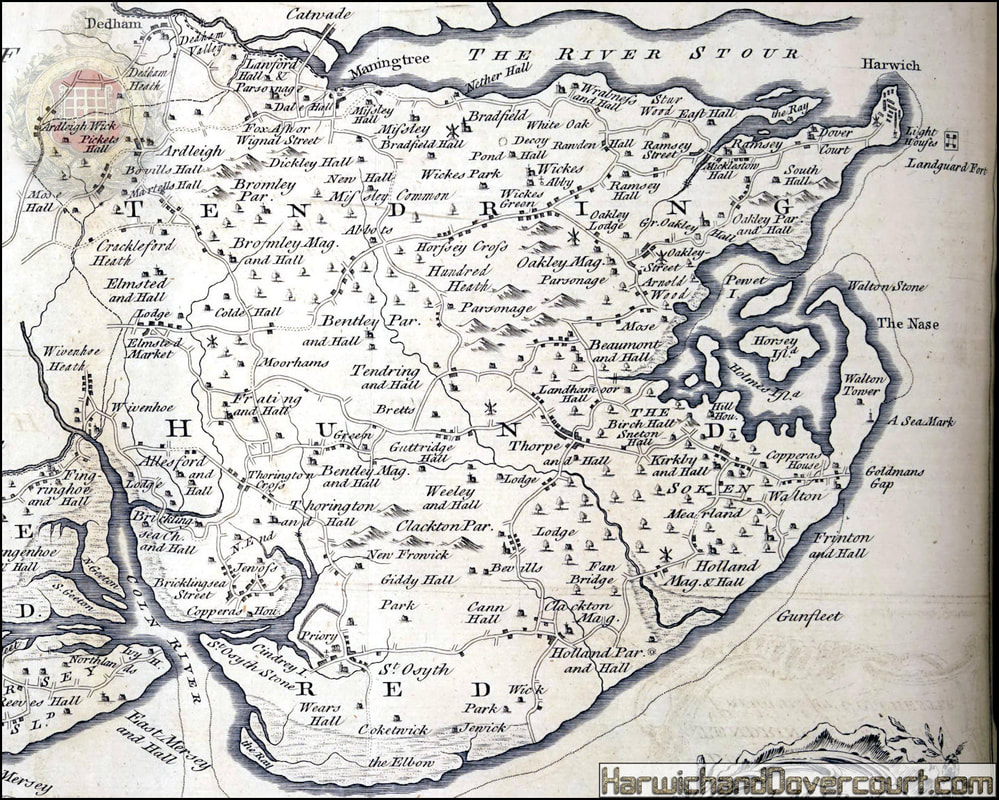
~ 1768 ~ A Map of the Hundreds of Thurstable, Winstree andTendring H&D ~
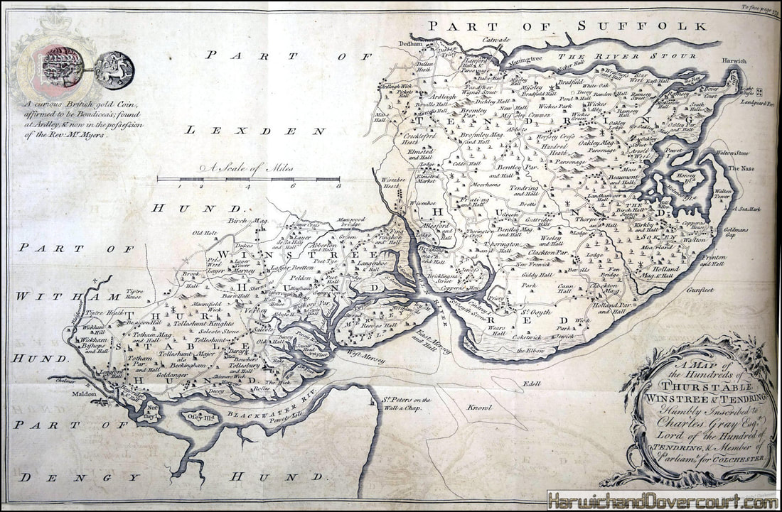
~ 1768 ~ A Map of the Hundreds of Thurstable, Winstree andTendring H&D ~
~ Detailed Tendring Section ~
~ 1777 ~ A Map of the County of Essex by John Chapman & Peter André H&D ~ Front ~
~ An Essex fulling mill with two cloth beaters and Harwich and Dovercourt churches in the background ~
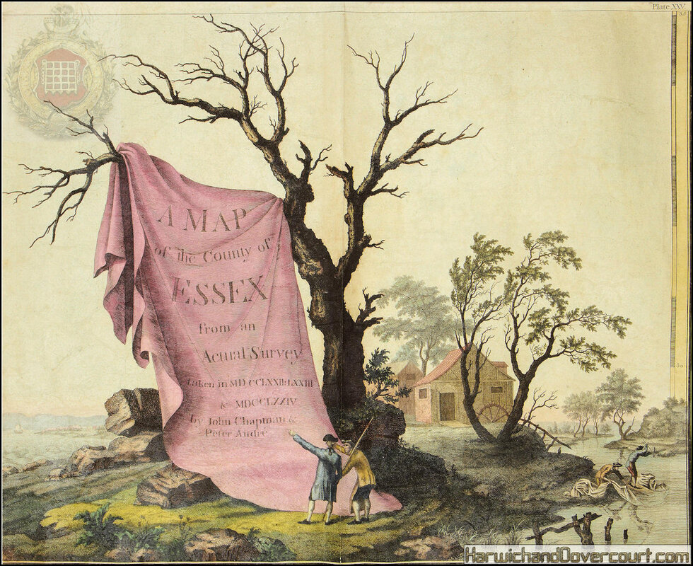
A Map of the County of Essex From an Actual Survey made in MDCCLXXII,
MDCCLXXIII and MDCCLXXIV by John Chapman and Peter Andre.
Author
John Chapman & Peter Andre
Publication date
1777-[June 1785].
Publication place
London
Physical description
Folio (440 by 390 mm), index map, and 25 double-page engraved map sheets, all with fine original hand-colour, some minor offsetting, modern half calf over marbled paper boards.
Notes
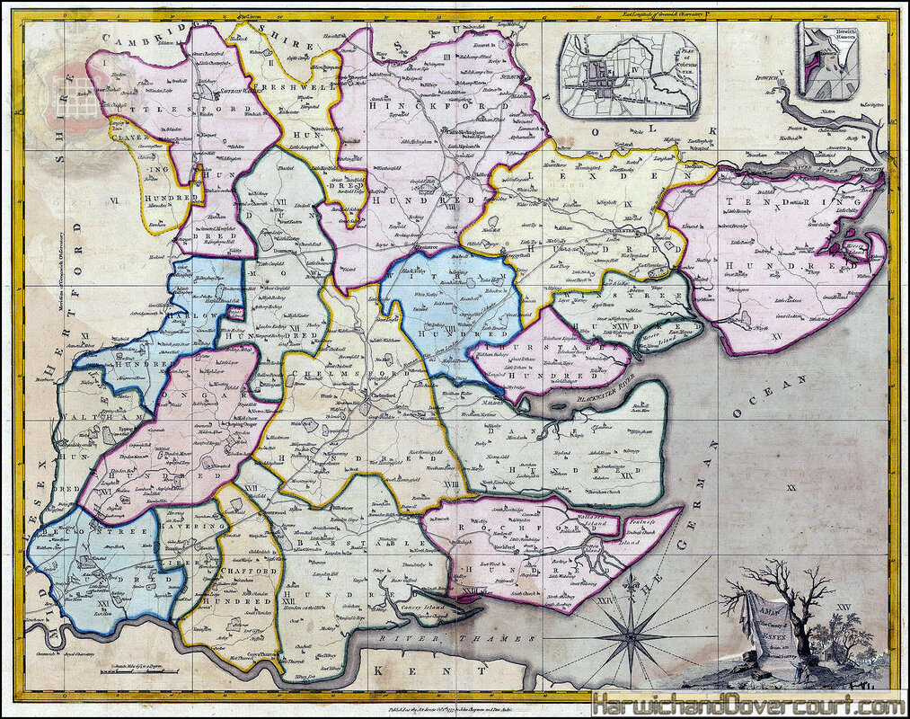
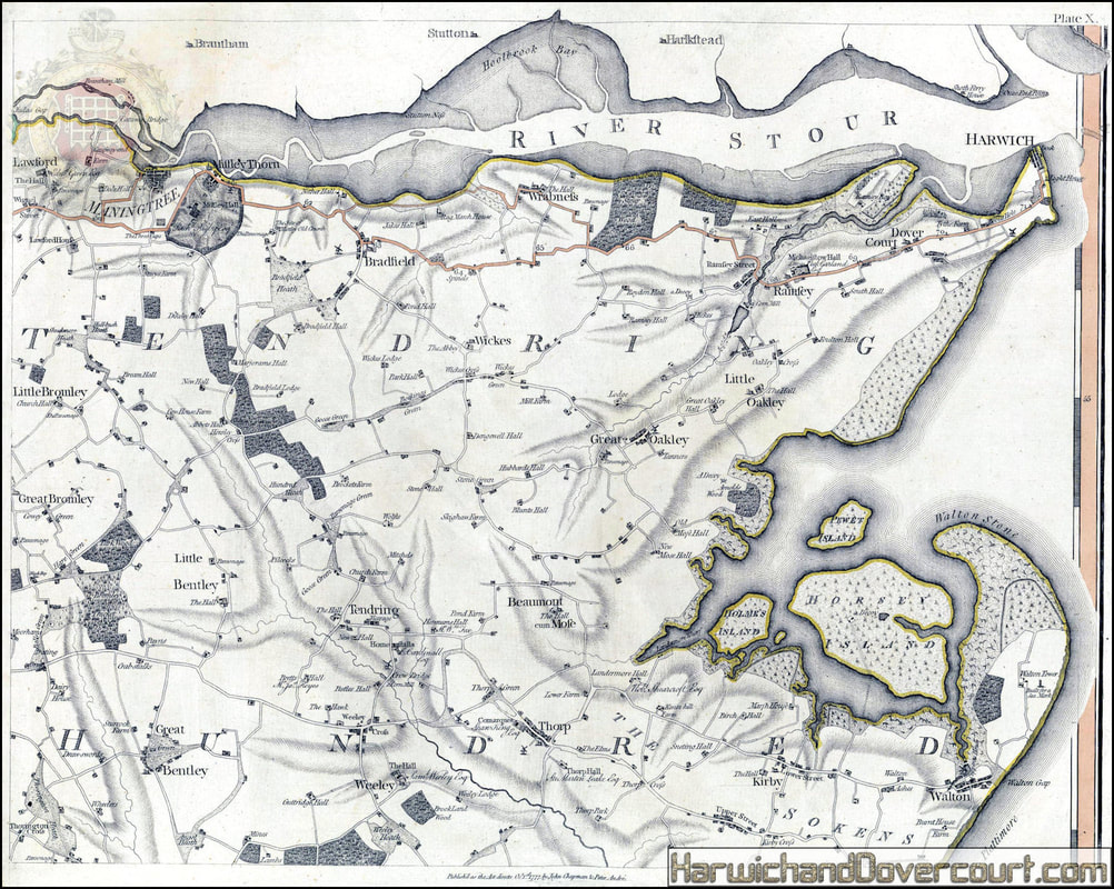
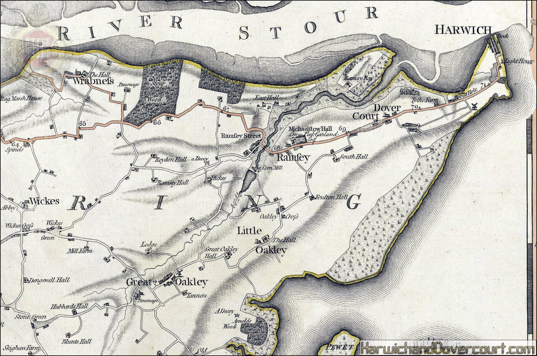
Chapman and André's survey of Essex was one of the most celebrated of the nineteenth century large-scale maps with a wealth of detail matched by extraordinary accuracy, even when checked against large-scale contemporary estate maps. Minor roads were depicted on a map of the county for the first time with bridges, milestones and turnpike gates, whilst on the long coastline every creek, wharf, quay, ferry, duck decoy and cliff is shown.
The countryside is extensively delineated with hills, woods, parks and heaths clearly depicted and often named. Except in the towns and villages, nearly every house and cottage is marked, whilst the principal seats and their owners, and most of the manor houses, and farm houses are named. There are complete sheets devoted to the vignette title (an Essex fulling mill with two cloth beaters and Harwich and Dovercourt churches in the background), and a
list of 240 subscribers.
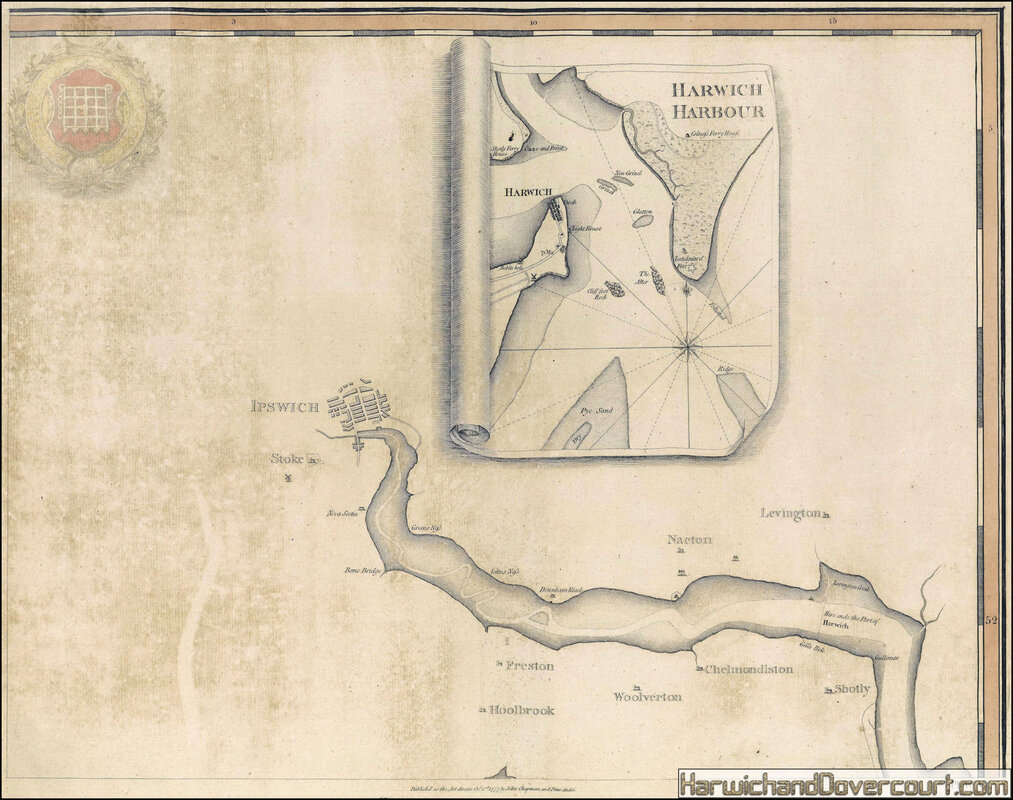
Further sheets include a general map of the county to serve as a key map, an outline of Harwich Harbour and a plan of Colchester on a scale of 168 yards to the inch including information about the town such as fairs and market days. It is unlikely that more than 300 copies of this edition were sold, though there was a second smaller edition issued in 1785.
The twenty-one sheets covering the survey of the county, together with the rest of the atlas, are all fully coloured by a contemporary hand to make it one of the most competent and attractive of the large-scale surveys.
MDCCLXXIII and MDCCLXXIV by John Chapman and Peter Andre.
Author
John Chapman & Peter Andre
Publication date
1777-[June 1785].
Publication place
London
Physical description
Folio (440 by 390 mm), index map, and 25 double-page engraved map sheets, all with fine original hand-colour, some minor offsetting, modern half calf over marbled paper boards.
Notes
Chapman and André's survey of Essex was one of the most celebrated of the nineteenth century large-scale maps with a wealth of detail matched by extraordinary accuracy, even when checked against large-scale contemporary estate maps. Minor roads were depicted on a map of the county for the first time with bridges, milestones and turnpike gates, whilst on the long coastline every creek, wharf, quay, ferry, duck decoy and cliff is shown.
The countryside is extensively delineated with hills, woods, parks and heaths clearly depicted and often named. Except in the towns and villages, nearly every house and cottage is marked, whilst the principal seats and their owners, and most of the manor houses, and farm houses are named. There are complete sheets devoted to the vignette title (an Essex fulling mill with two cloth beaters and Harwich and Dovercourt churches in the background), and a
list of 240 subscribers.
Further sheets include a general map of the county to serve as a key map, an outline of Harwich Harbour and a plan of Colchester on a scale of 168 yards to the inch including information about the town such as fairs and market days. It is unlikely that more than 300 copies of this edition were sold, though there was a second smaller edition issued in 1785.
The twenty-one sheets covering the survey of the county, together with the rest of the atlas, are all fully coloured by a contemporary hand to make it one of the most competent and attractive of the large-scale surveys.
~ 1777 ~ A Map of the County of Essex by John Chapman & Peter André H&D ~ Sections ~
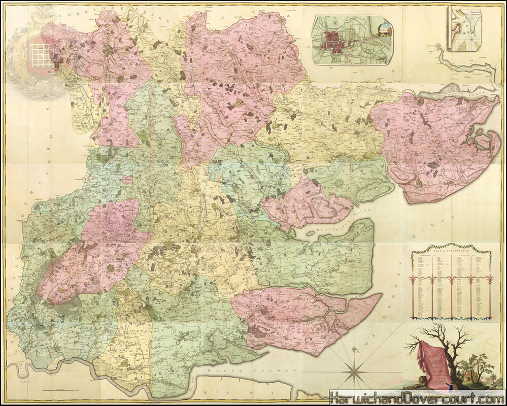
~ 1777 ~ A Map of the County of Essex by John Chapman & Peter André H&D ~ Boundaries~
~ 1777 ~ A Map of the County of Essex by John Chapman & Peter André H&D ~ Tendring ~
~ 1777 ~ A Map of the County of Essex by John Chapman & Peter André H&D ~
~ Harwich Residential Area ~
~ 1777 ~ A Map of the County of Essex by John Chapman & Peter André H&D ~
~ Harwich Harbour ~
~ 1777 ~ A Map of the County of Essex by John Chapman & Peter André H&D ~
~ Harwich Harbour Area ~
~ 1778 ~ Emanuel Bowen ~ An Accurate Map Of The County Of Essex H&D ~

Handsome copper-engraved map of Essex surrounded by descriptive text about the towns and cities, the local nobility, and the industries of the county. Features a decorative title cartouche. Original hand colour.
~ 1778 ~ Emanuel Bowen An Accurate Map Of The County Of Essex H&D ~
~ A Detailed Section N.E. Essex ~
~ 1779 ~ Antonio Zatta Provinicia Di Essex H&D ~
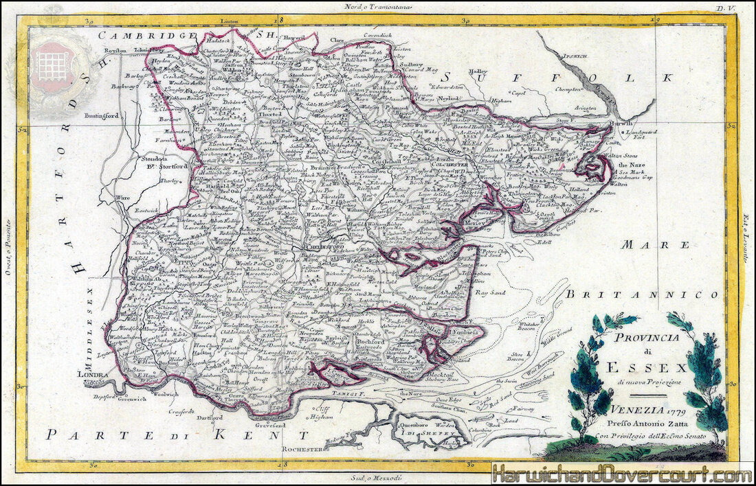
An Attractive Italian county map of Essex with illustrated cartouche. Original colour.
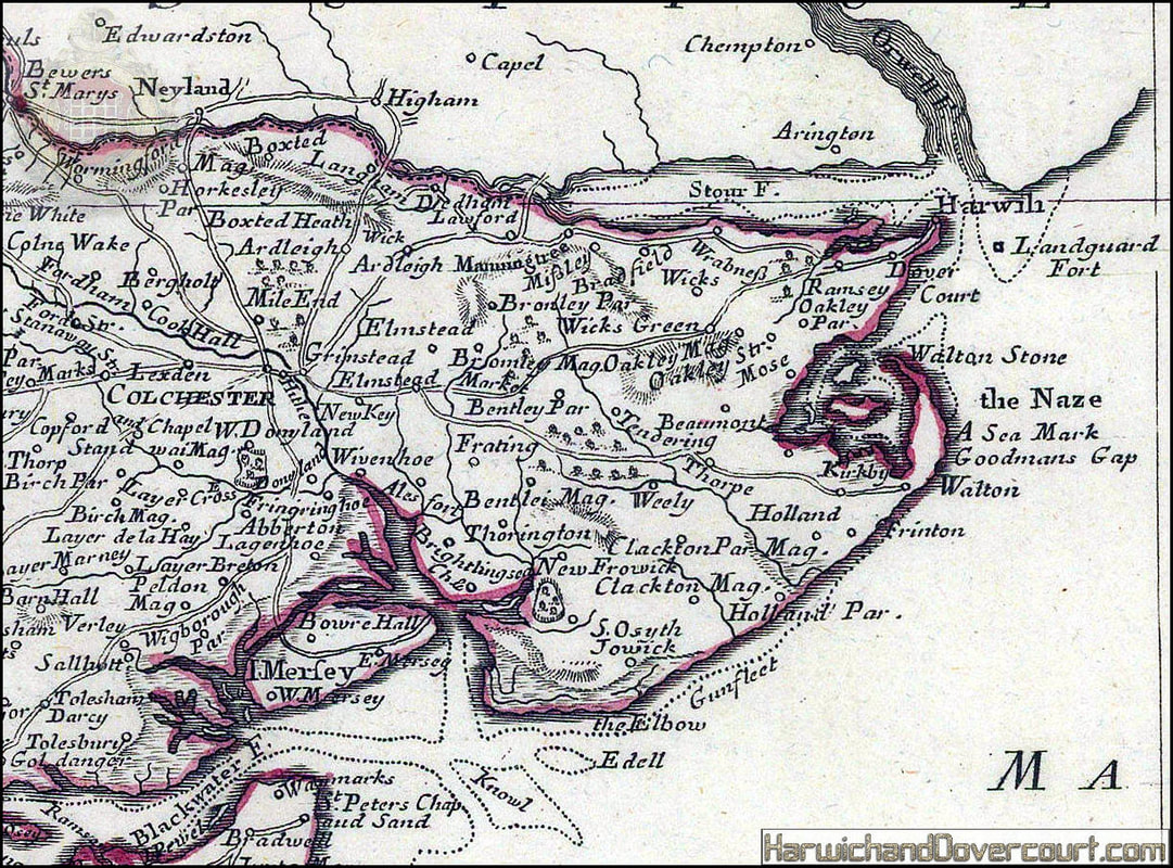
~ 1779 ~ Antonio Zatta Provinicia Di Essex H&D ~ Detailed Section N.E. Essex ~
~ 1780 ~ Map Of Essex by Grose H&D ~
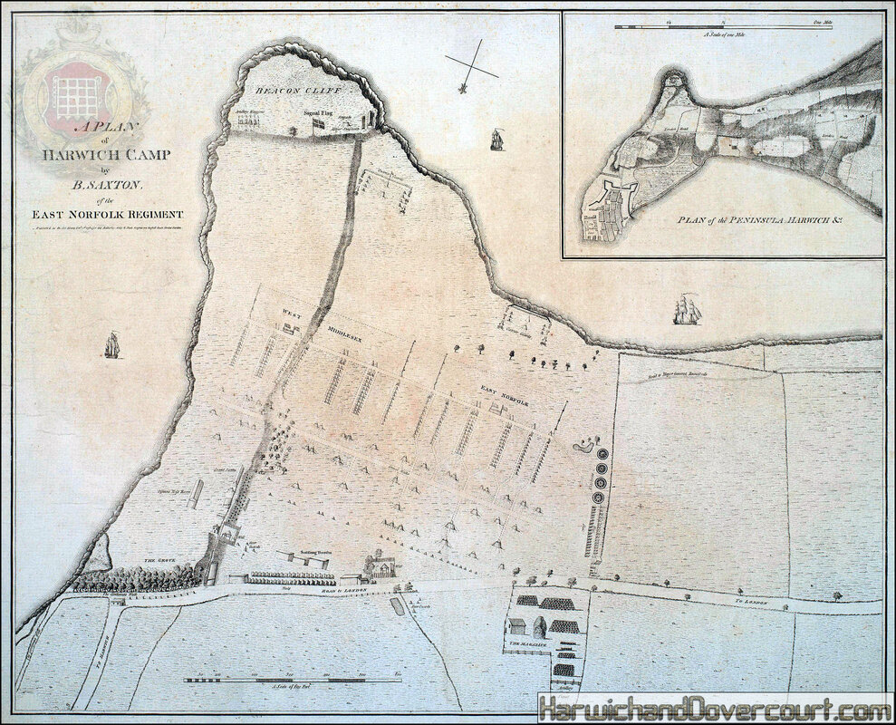
~ 1781 ~ A plan of Harwich Camp by B.Saxton H&D ~
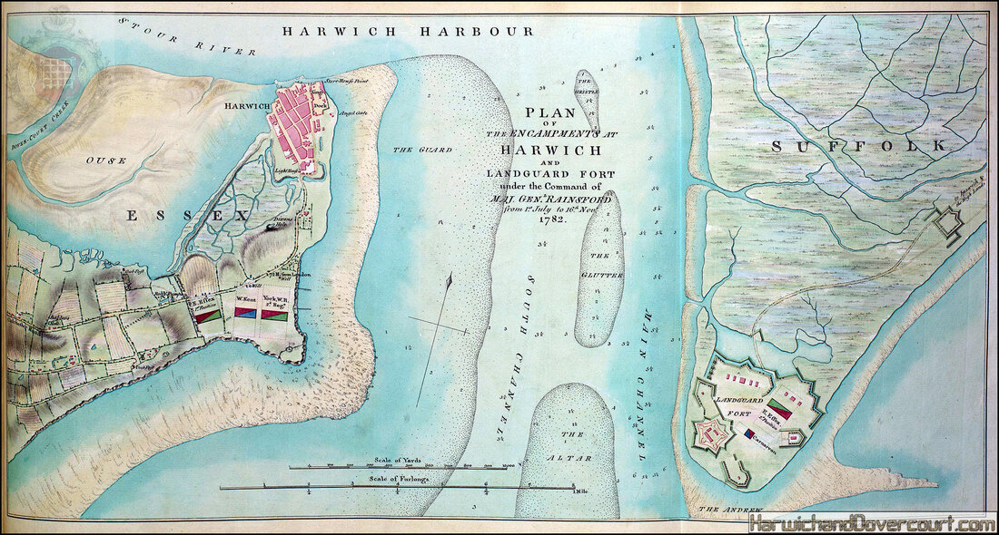
~ 1782 ~ Plan of the Encampments at Harwich H&D ~
~ 1785 ~ Capt. Greenvile-Collins English Sea-Chart of the North Sea H&D ~
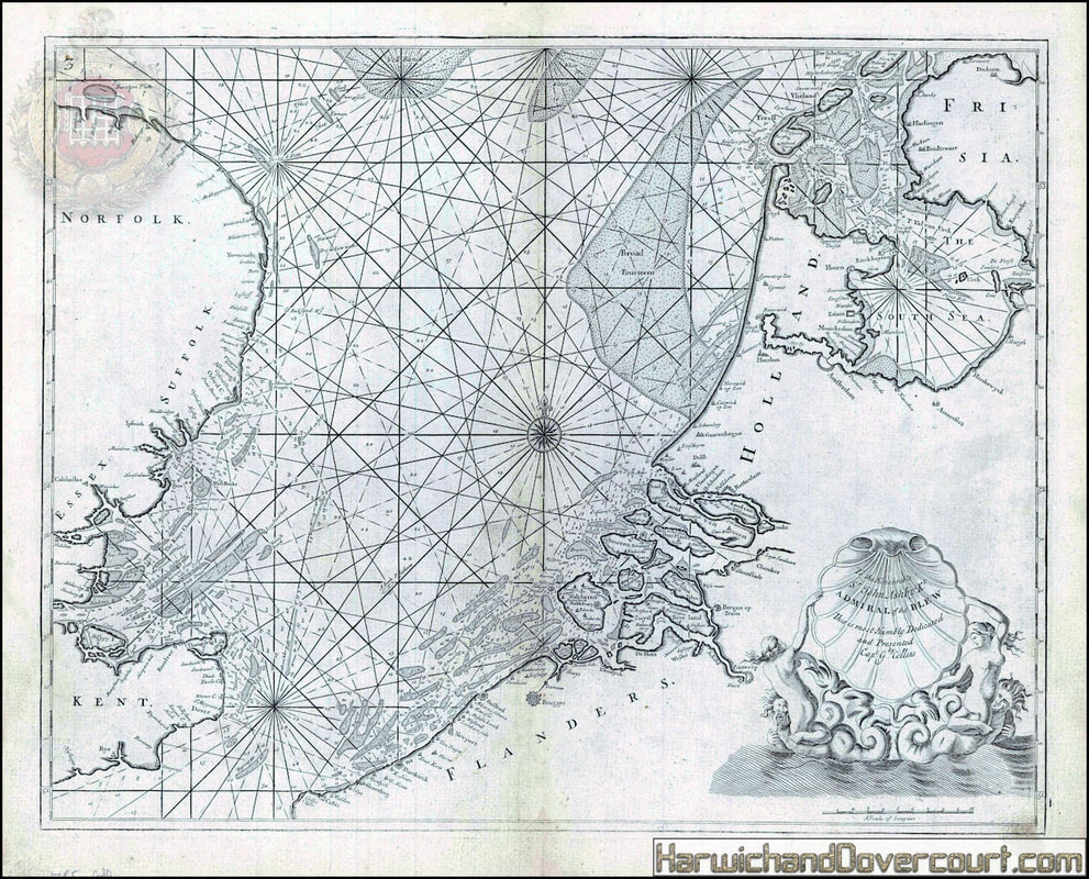
~ 1785 ~ Capt. Greenvile-Collins English Sea-Chart of the North Sea H&D ~
~ 1785 ~ Green & Tufnell's ~ Road Map from Manningtree to Harwich H&D ~

London to Chelmsford Colchester & Harwich measured from White Chapel Church] : Manningtree - Harwich // London to Bury St. Edmds. commencing at Chelmsford : Chelmsford - Braintree. Essex
Date Printed 1785 , Image Size 17.5 x 10.0cm, 7 x 4 inches (Small)
Type : Antique copperplate road strip map
Cartographer : Daniel Paterson
Provenance: "Paterson's British Itinerary"; By Daniel Paterson, Esq.,
Printed and sold for by Proprietor, Carington Bowles, 69 St. Paul's Churchyard, London
Date Printed 1785 , Image Size 17.5 x 10.0cm, 7 x 4 inches (Small)
Type : Antique copperplate road strip map
Cartographer : Daniel Paterson
Provenance: "Paterson's British Itinerary"; By Daniel Paterson, Esq.,
Printed and sold for by Proprietor, Carington Bowles, 69 St. Paul's Churchyard, London
~ 1786 ~ Robert Sayer A New Hydrographic Sketch ~
~ Covering the North, South and Middle Channels H&D ~
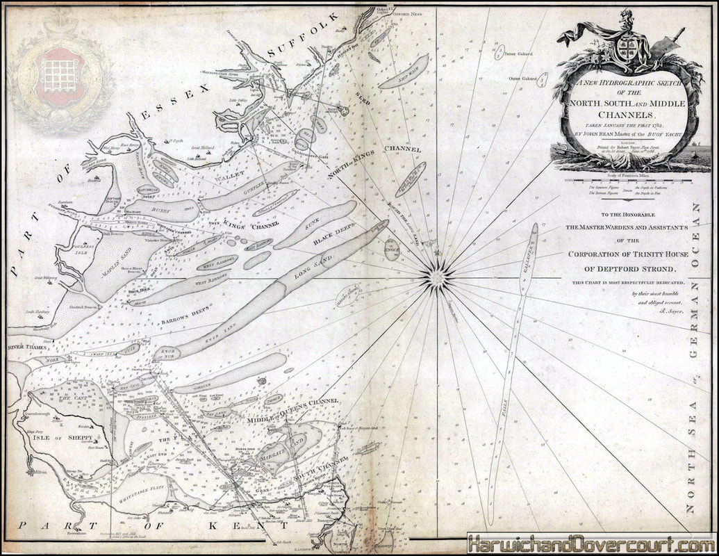
A New Hydrographic Sketch of the North, South and Middle Channels
Splendid, detailed sea chart of the approaches to the mouth of the Thames marking the notorious sand banks which were so hazardous to shipping. The map also marks the safe channels through the Sands onto the coasts of Suffolk, Essex and Kent and ultimately to the mouth of the Thames. The map was sourced from the survey made by John Bean, Master of the Buoy Yacht and the dedication is to the Master, Warden and Assistants of the Corporation of Trinity House.
Splendid, detailed sea chart of the approaches to the mouth of the Thames marking the notorious sand banks which were so hazardous to shipping. The map also marks the safe channels through the Sands onto the coasts of Suffolk, Essex and Kent and ultimately to the mouth of the Thames. The map was sourced from the survey made by John Bean, Master of the Buoy Yacht and the dedication is to the Master, Warden and Assistants of the Corporation of Trinity House.
~ 1787 ~ John Seller Essex Map H&D ~
Essex. Miniature county map. Coloured.
John Seller , 1787
John Seller , 1787
~ 1793 ~ John Cary Map of Essex H&D ~
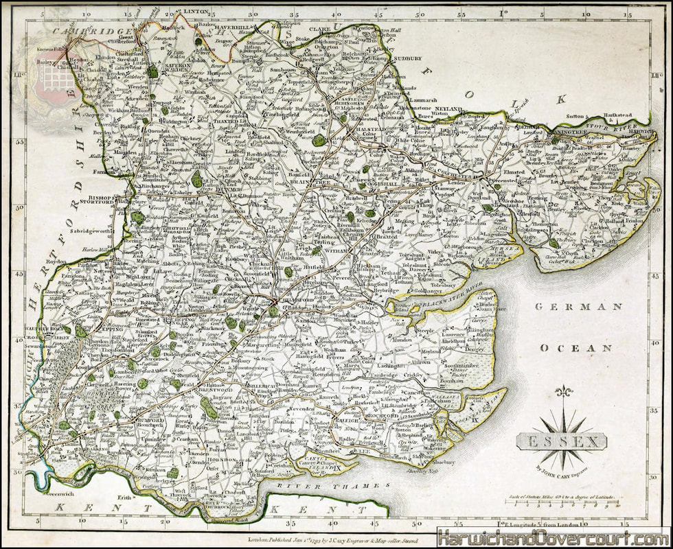
Fine late 18th Century county map of Essex and the mouth of the River Thames, showing the developing road network and mapping country estates.
Original colour.
Original colour.
~ 1793 ~ John Cary Map of Essex H&D FW ~ Detailed Section N.E. Essex ~
~ 1794 ~ A New Chart of Harwich Harbour ~ Presented to the Hon.ble Capt.n James Lutterell ~

~ 1794 ~ A New Chart of Harwich Harbour ~ Details of Harwich Harbour ~

A New Chart of Harwich Harbour with the Rolling Ground, Felstow Road, Goldermore's and Flats of the Naze most humbly Inscribed and Presented to the Hon.ble Capt.n James Lutterell.
Harwich was important as the only safe anchorage on the east coast of England between the Thames and Humber. As such it was important for the Royal Navy, especially at the time this chart was published, as invasion by Revolutionary France was feared.
London: Laurie & Whittle, 1794. 520 x 510mm.
Harwich was important as the only safe anchorage on the east coast of England between the Thames and Humber. As such it was important for the Royal Navy, especially at the time this chart was published, as invasion by Revolutionary France was feared.
London: Laurie & Whittle, 1794. 520 x 510mm.