~ Essex & Suffolk ~ Sea Charts, Town Plans & Maps ~
~ 1801 ~ John Carey - A New Map Of Essex H&D ~
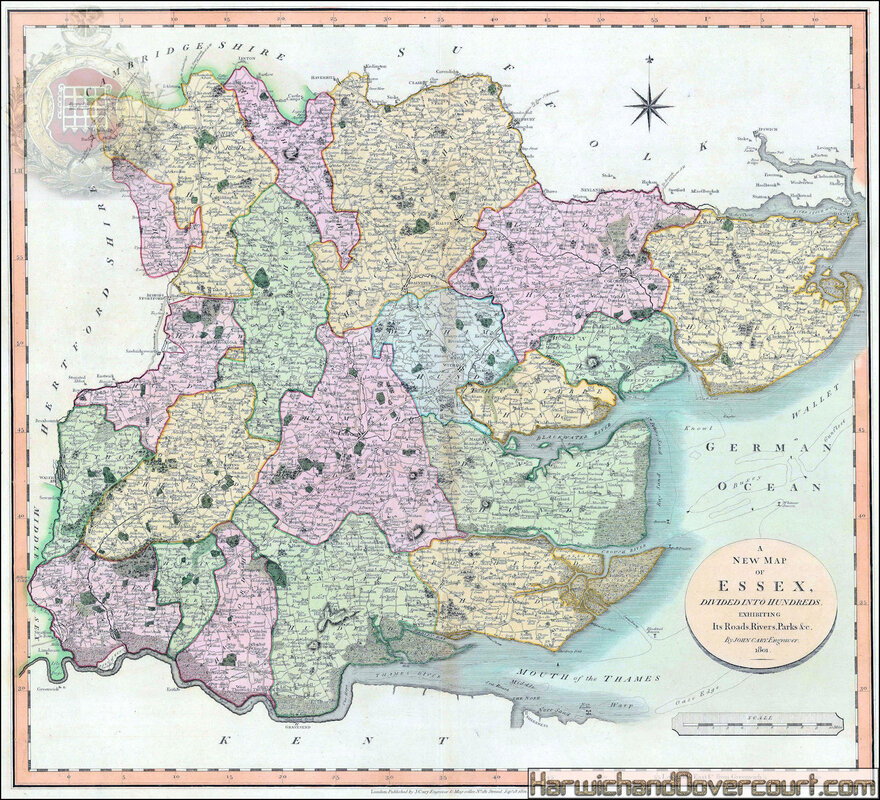
An attractive county map of Essex by the cartographer to the Postmaster General, accurately plotting England's roads.
Original colour.
Original colour.
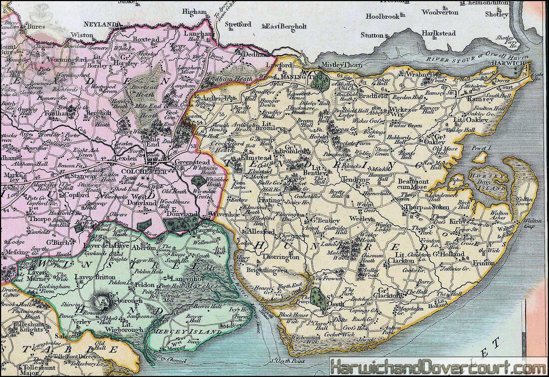
~ 1801 ~ John Carey - A New Map Of Essex H&D ~
~ A detailed section from N.E. Essex ~
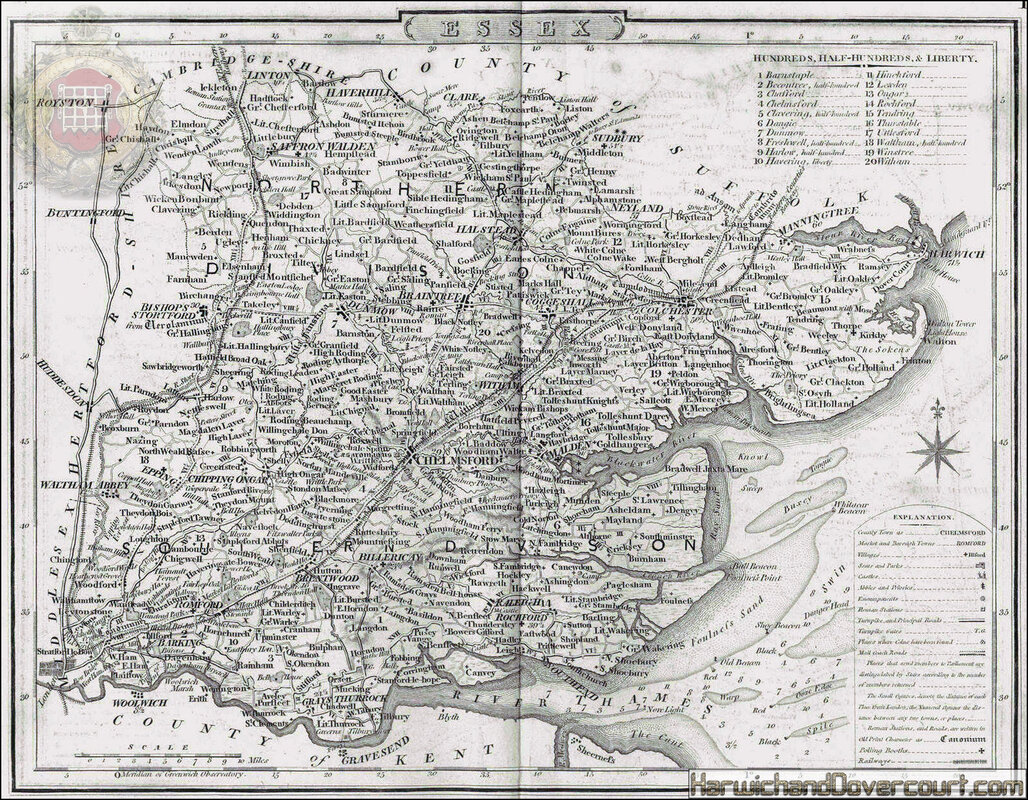
~ 1803 ~ John Wilkes Essex Map H&D ~
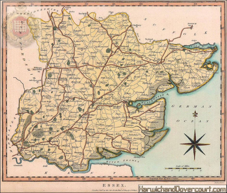
County map of Essex with towns, post roads, and enclosed estates marked.
Fine original hand-colour.
Published in the Encyclopaedia Londinensis; or, universal dictionary of arts, sciences, and literature.
Engraved by Samuel James Neele.
Fine original hand-colour.
Published in the Encyclopaedia Londinensis; or, universal dictionary of arts, sciences, and literature.
Engraved by Samuel James Neele.
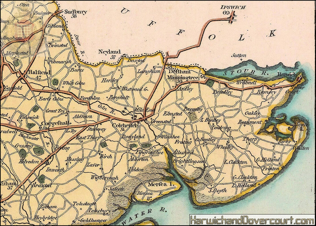
~ 1803 ~ John Wilkes Essex Map H&D ~
~ A detailed section from N.E. Essex ~
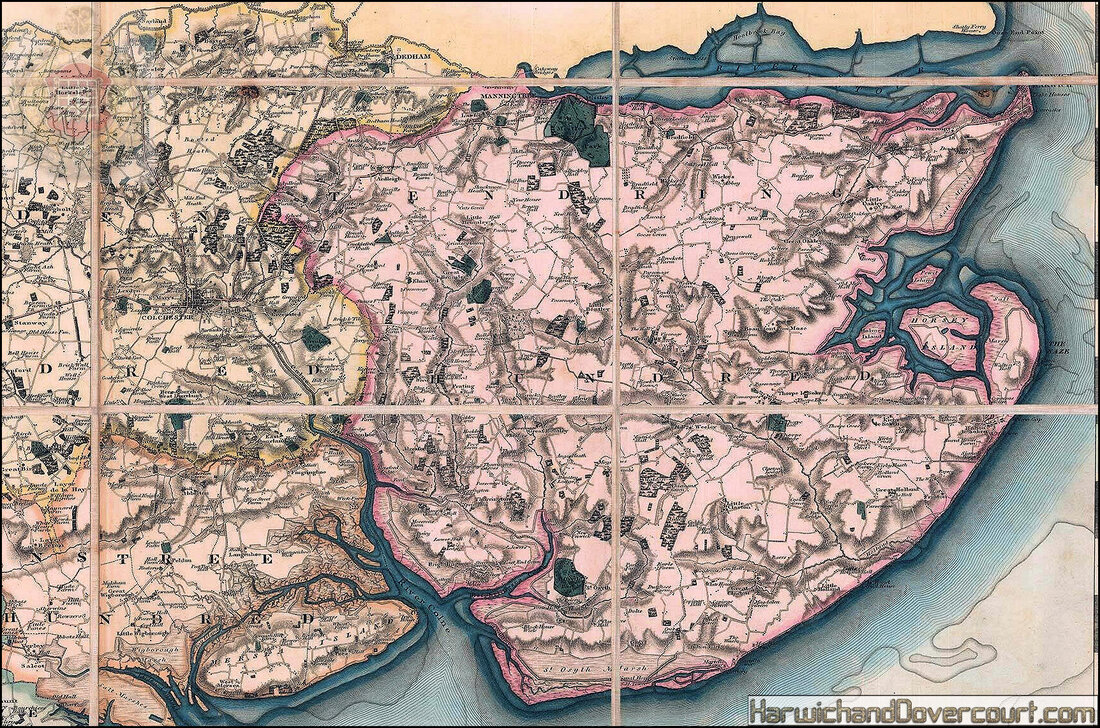
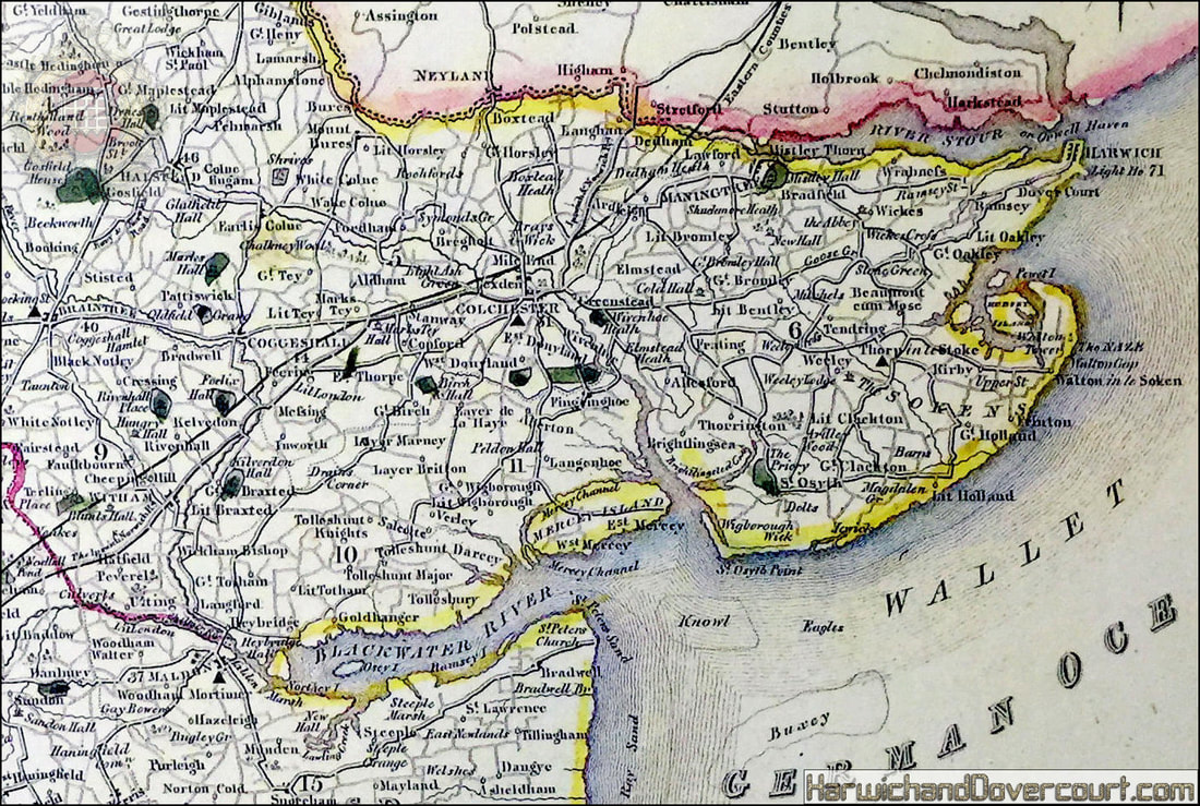
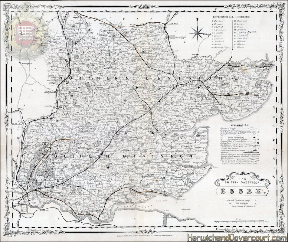
~ 1805 ~ John Cary - A map of Essex from the best authorities H&D ~
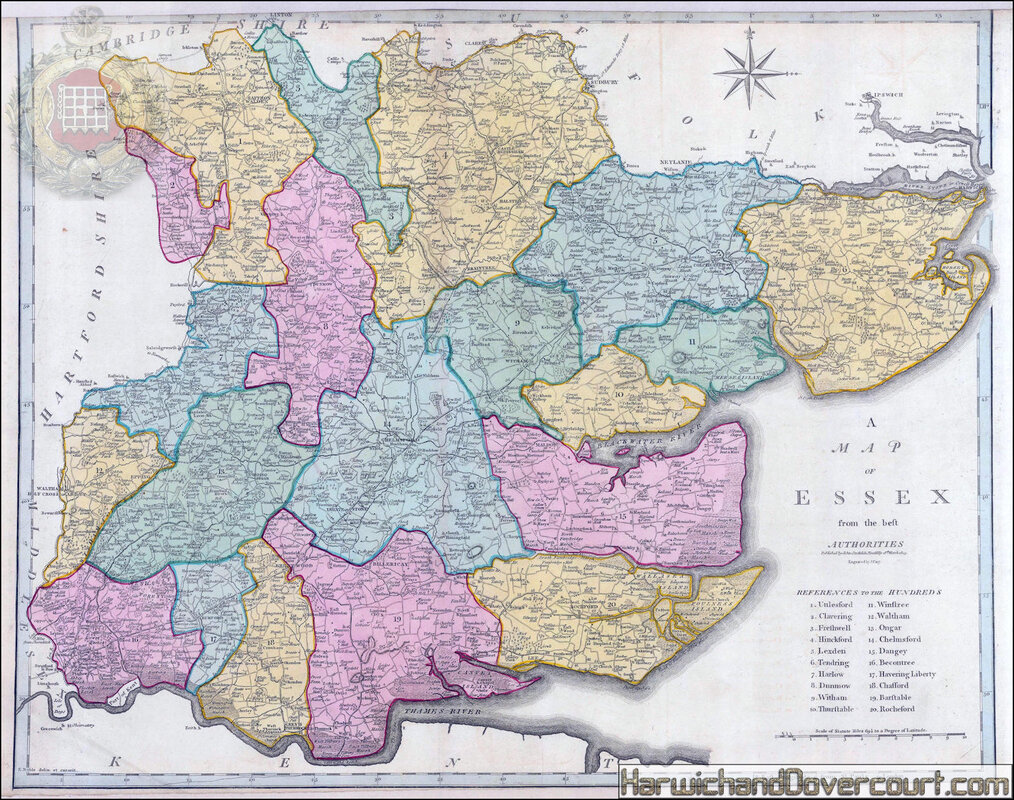
John Cary, 1805
A Map of Essex from the Best Authorities
Essex, fine county map with reference to the Hundreds and showing the course of the River Thames into London.
Attractive map of the county of Essex highlighting the developing road network during the Industrial Revolution.
Original hand colour.
A Map of Essex from the Best Authorities
Essex, fine county map with reference to the Hundreds and showing the course of the River Thames into London.
Attractive map of the county of Essex highlighting the developing road network during the Industrial Revolution.
Original hand colour.
~ 1805 ~ John Cary - A map of Essex from the best authorities H&D ~
~ A detailed section from N.E. Essex ~
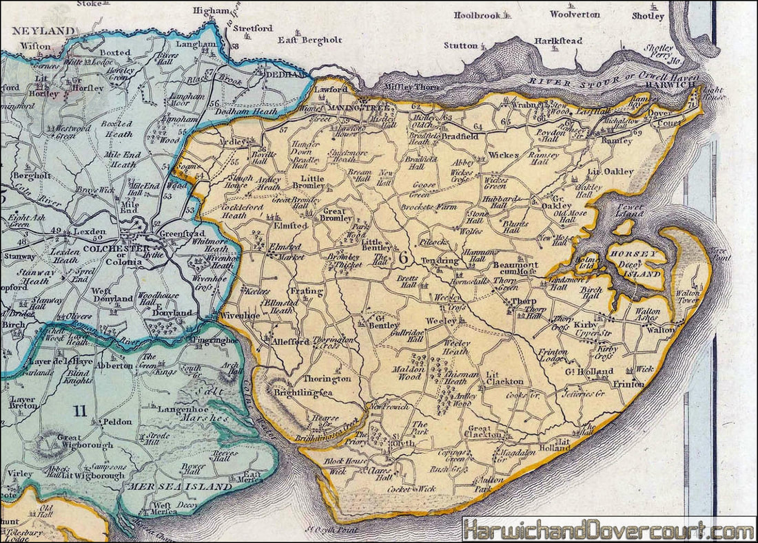
~ 1805 ~ John Cary - A map of Essex from the best authorities H&D ~
~ 1805 ~ John Cary - A map of Essex from the best authorities H&D ~
~ A detailed section from N.E. Essex ~
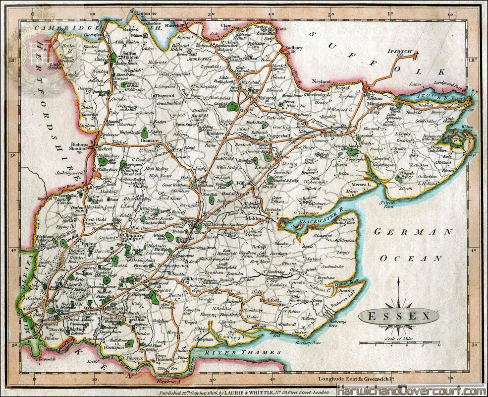
~ 1806 ~ Laurie & Whittle Map of Essex H&D ~
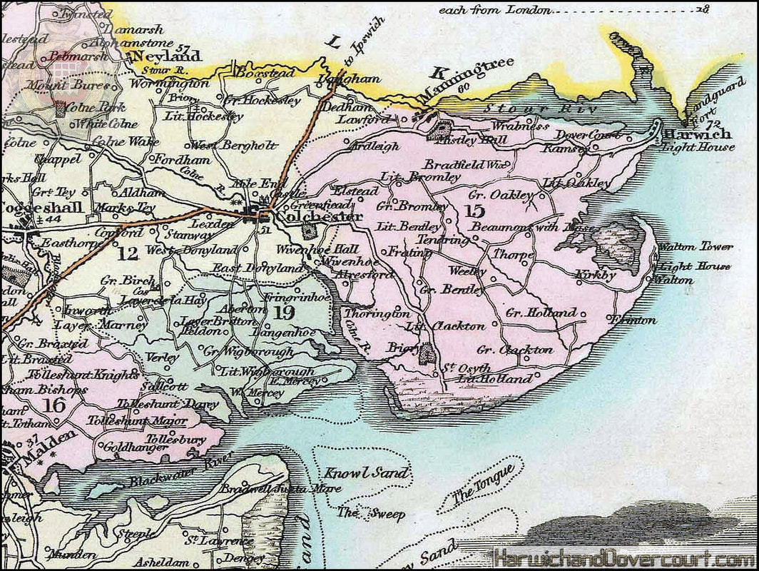
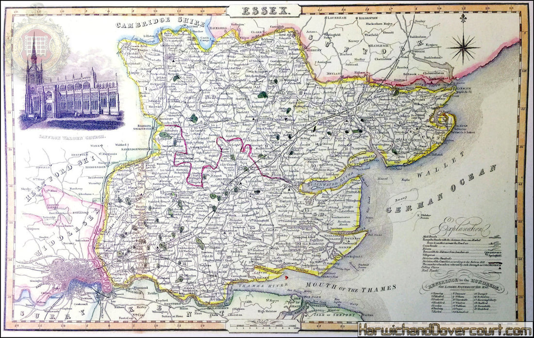
~ 1817 ~ Langley & Belch New Map Of Essex H&D ~
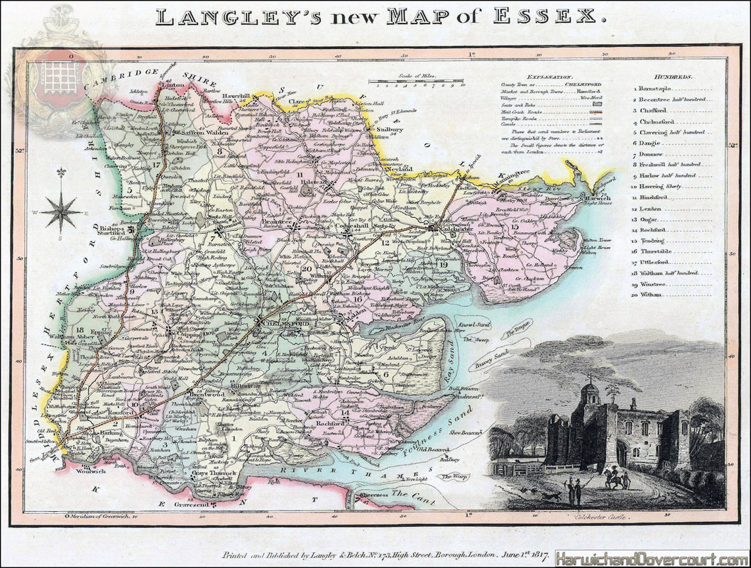
Langley & Belch , 1817
Langley's New Map of Essex
Essex, divided into hundreds and featuring elegant vignette of Colchester Castle. Original colour.
Langley's New Map of Essex
Essex, divided into hundreds and featuring elegant vignette of Colchester Castle. Original colour.
~ 1817 ~ Langley & Belch New Map Of Essex H&D ~
~ A detailed section from N.E. Essex ~
~ 1820 ~ Geological Map of Essex, by W. Smith, Mineral Surveyor H&D ~
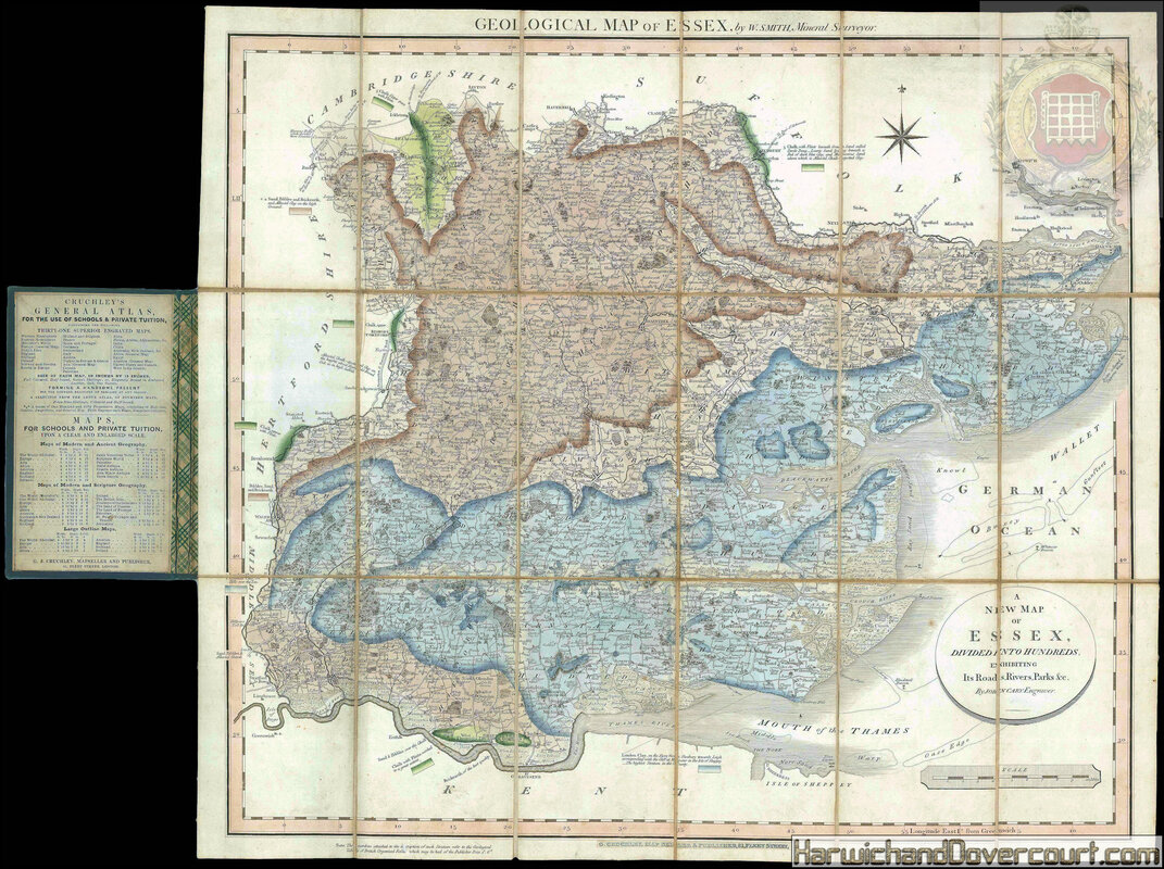
Geological Map of Essex, by W. Smith, Mineral Surveyor.
Author
William Smith
Publication date
[1820, but issued after 1844].
Publisher
C. Cruchley, map seller & publisher, 81 Fleet Street.,
Publication place
London, England
Physical description
Engraved map, fine original hand-colour, dissected and mounted on linen, Cary's imprint pasted over with
Cruchley's, folding into original blue cloth covers with publisher's label.
Dimensions
517 by 577mm. (20.25 by 22.75 inches).
Notes
This geological map of Essex was made by William Smith as part of his series of county maps, each separately issued, which were the first detailed geological maps of specific areas. These individual maps are extremely rare on the market.
In 1815, Smith had produced the first geological map of England and Wales, which contained "an amazing amount of correct detail" (DSB) and was the basis for all the geological maps that followed. In 1819 he began the publication of a geological atlas of England and Wales. Published in parts over five years, it remained unfinished, and contains 21 maps of various English counties.
The map of Essex appeared in the third part (1820), and was also issued separately, as here. His county maps are based on those of John Cary, with geological data added from Smith's own surveys. They are headed 'By W. Smith, Mineral Surveyor.' and the title above appears in the upper margin; another title is given in a circular tablet in the lower left corner: "A New Map of Essex, divided into hundreds, exhibiting Its Roads, Rivers, Parks &c. By John Cary, Engraver." Smith's survey of Essex reveals the county's vast stores of clay, interspersed with chalk deposits. Some additional details are noted beside individual keys, for example, he describes the sedimentary layers along the border with Suffolk, identifies the Southern region as "the highest stratum in the County" and explains that the chalk in Thurrock had been "worked to a great extent". Along the lower border of the map, a note explains that the numbers used to describe each Stratum "refer to the Geological Table of British Organised Fossils, which may be had of the Publisher Price 1 s[hilling]". Coincidentally, this work was also one of Smith's. His self-promotion continues with another note on the opposite side, advertising "Geological Sections of the Strata through Essex on the Road from London to Cambridge, by W. Smith".
The compass is found in the upper right corner and the scale in the lower, while the decorative border also contains the lines of longitude and latitude. Although originally published by Cary, this map was issued by George Cruchley, who purchased the plates from Cary's sons after his death in 1836. Cruchley promoted his maps as a cheaper alternative to an expensive Ordnance or Cary map, his slogan being "Half the Scale, Half the Price". The inside label on the covering of this map suggests that it would make "a handsome present for the younger branches of families at any season".
Map publishers and sellers such as Cruchley were central to the shift in cartography that occurred during the nineteenth century, by which maps were no longer the exclusive preserve of the wealthy and education, but became more widely available to the public.
~ 1820 ~ Geological Map of Essex, by W. Smith, Mineral Surveyor H&D ~
~ A detailed section from N.E. Essex ~
~ 1823 ~ Greenwood’s Large Scale Map of Essex H&D ~
Map of the County of Essex, from an actual Survey made in the Year 1824, By C. & I. Greenwood, most respectfully Dedicated to the Nobility, Clergy and Gentry of the County by the Proprietors Greenwood, Pringle & Co.
Author
Christopher Greenwood
Publication date
June 1st, 1823.
Publisher
Published by Greenwood, Pringle & Co.
Publication place
London, Englamd
Physical description
Large engraved map on four sheets, dissected and mounted on linen, in two sections, original full wash hand
colour, edged in green silk, housed in original tree calf pull-off slipcase, red morocco label to spine, lettered in gilt,
rubbed.
Dimensions
1340 by 1550mm. (52.75 by 61 inches).
Notes
The maps by Christopher and John Greenwood set new standards for large-scale surveys. Although they were unsuccessful in their stated aim to map all the counties of England and Wales it is probably no coincidence that of the ones they missed, Buckinghamshire, Cambridgeshire, Herefordshire, Hertfordshire, Norfolk and Oxfordshire, all except Cambridgeshire were mapped by Andrew Bryant in a similar style and at the same period. From a technical point of view the Greenwoods' productions exceeded the high standards set in the previous century though without the decoration and charming title-pieces that typified large scale maps of that period.
The Greenwoods started in 1817 with Lancashire and Yorkshire and by 1831 they had covered 34 counties. Their maps were masterpieces of surveying and engraving techniques, and in view of the speed at which they were completed, their accuracy is remarkable. They mark the boundaries of the counties, hundreds and parishes, churches and chapels, castles and quarries, farm houses and gentlemen's seats, heaths and common land, woods, parliamentary representatives and distances between towns.
The price of 3 guineas each compares with the the first edition Ordnance Survey sheets of 7s 6d, though the latter did not relate to complete counties
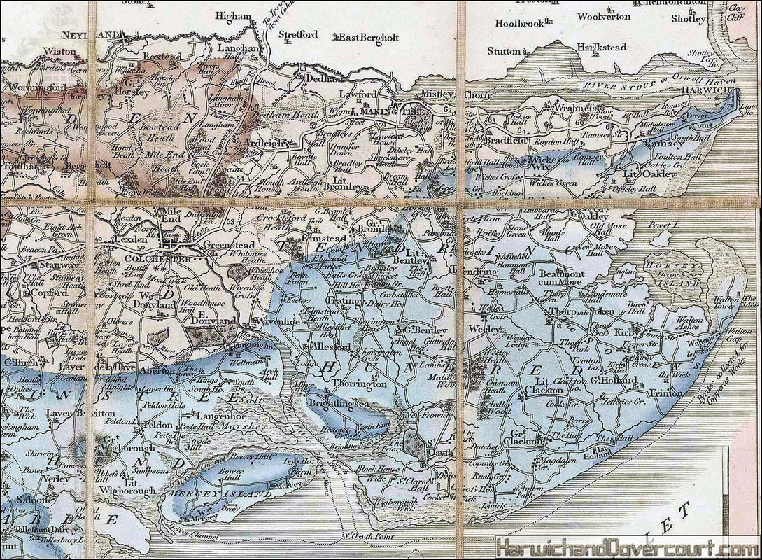
~ 1823 ~ Greenwood’s Large Scale Map of Essex H&D ~
~ A detailed section from N.E. Essex ~

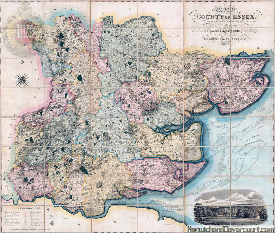
~ 1825 ~ Christopher John-Greenwood Map of the County of Essex H&D ~
1825 Christopher & John Greenwood
Map of the County of Essex, From an Actual Survey
A monumental, separately-issued, folding wall map of Essex in two sections. The lower right corner bears a large and intricate vignette of Audley End House near Saffron Walden, now an English Heritage property.
This map was produced as part of a series of extraordinary wall maps of the English counties by the Greenwood brothers, Christopher and John, in the early 19th century. Based on entirely new, exhaustive surveys, skilfully engraved, and delicately hand coloured in a uniform manner, these maps were luxury objects marketed to the newly wealthy Georgian public. The project was initiated in 1817, and by 1831, the Greenwood brothers had surveyed and published 34 county wall maps.
The quality of the engraving and colouring was the height of luxury for county maps of the age, and spawned multiple competitors, such as Henry Teesdale and Andrew Bryant. Unfortunately, due to increased competition and the use of expensive original surveys, the project was not a financial success and was never completed. With the failure of the project, the Greenwood brothers were forced to declare bankruptcy and to sell the rights to their maps to other publishers.
This example, rather curiously, bears the sales label of James Wyld the Elder (just underneath the engraved title), which is very unusual. It is likely that Wyld acquired a copy of this map at the request of a specific customer as we have seen no other examples of a Greenwood map with a Wyld sales label.
As with all Greenwood maps, the level of detail is exceptional. Individual buildings are marked in smaller villages, as are field boundaries, parks and estates, churches, canals, mills, and castles. Hills and raised grounds are shown using delicate hachuring, making them appear to rise off the page.
Original hand colour. Marbled slipcase.
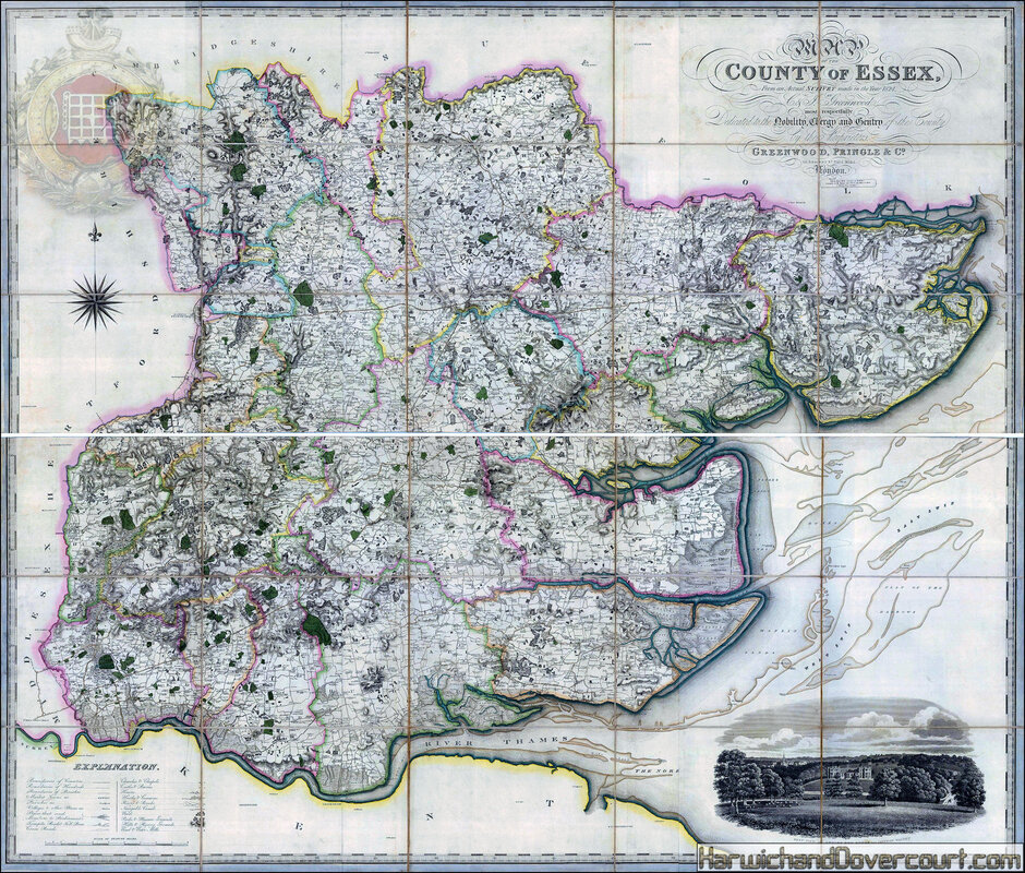
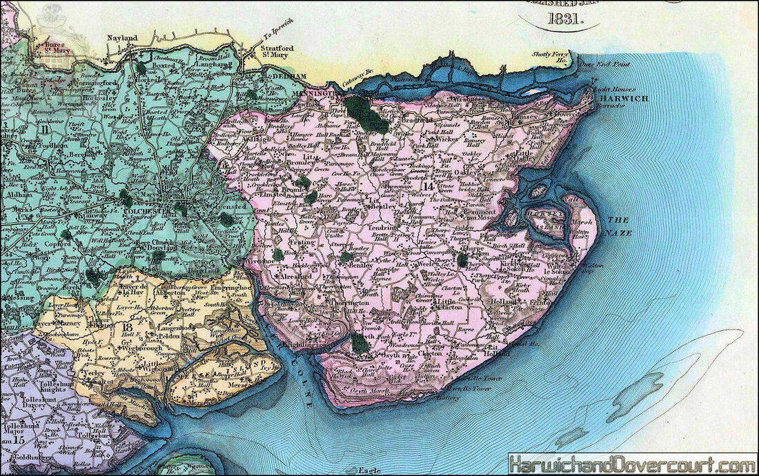
~ 1831 ~ Christopher John-Greenwood Map of the County of Essex H&D ~
1831 Christopher & John Greenwood , 1831
Map of the County of Essex from an Actual Survey made in the Year 1824
Stunningly engraved county map of Essex, with a grand title catouche and a decorative vignette of Audley End House near Saffron Walden.
The county has been divided into it's administrative 'hundreds' and details the developing road network.
The map extends north to show Cambridge, west to Hertford and Royston. The map also includes London and details the mouth of the River Thames
Original colour.
~ 1831 ~ Christopher John-Greenwood Map of the County of Essex H&D ~
~ A detailed section from N.E. Essex ~
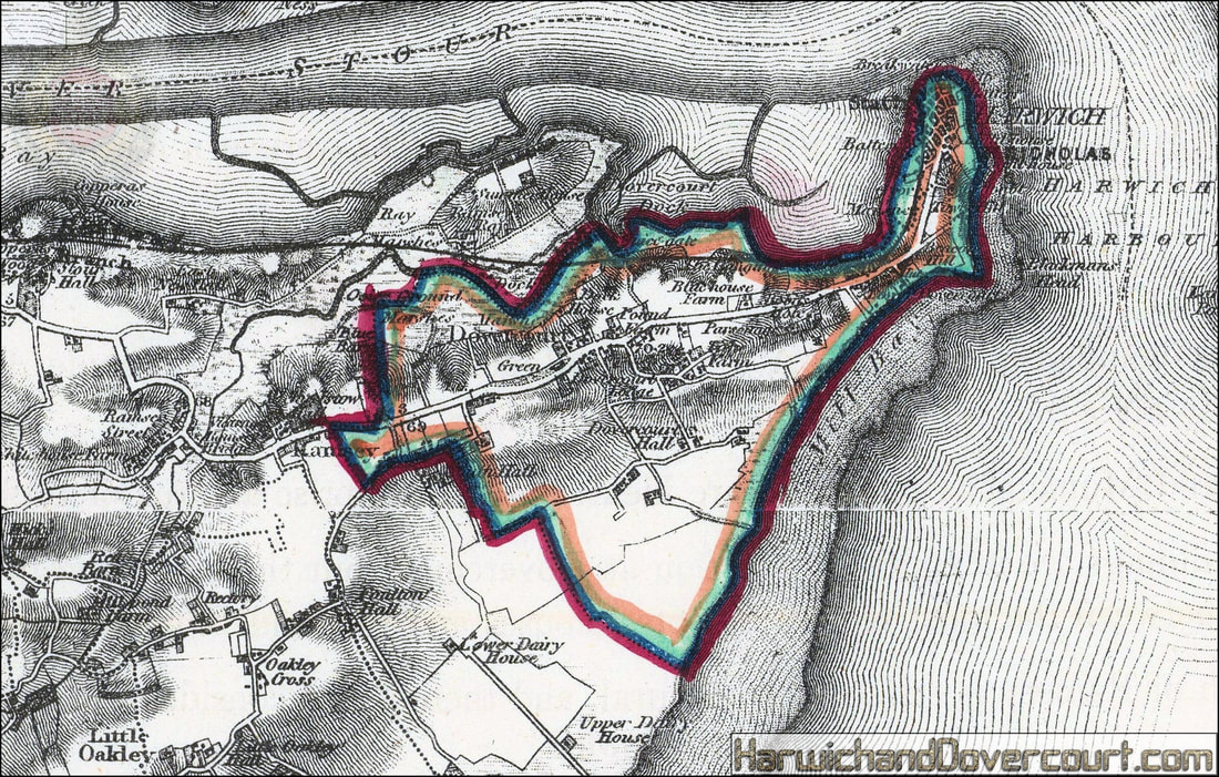
~ 1832 ~ Boundary Divisions H&D ~
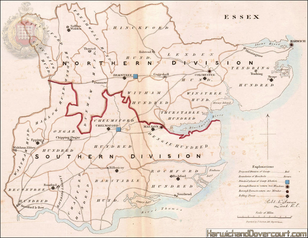
~ 1832 ~ Harwich Boundary Divisions H&D ~

Harwich borough / town plan for the Reform Act.
Essex. Dawson ~ 1832 old map
'Harwich'. Cartography by Robert K. Dawson Lieut. R.E. Lithography by R. Cartwright. (1832).
Antique lithographic map with original outline hand colour, 25.0 x 18.0cm, 9.75 x 7 inches
Essex. Dawson ~ 1832 old map
'Harwich'. Cartography by Robert K. Dawson Lieut. R.E. Lithography by R. Cartwright. (1832).
Antique lithographic map with original outline hand colour, 25.0 x 18.0cm, 9.75 x 7 inches
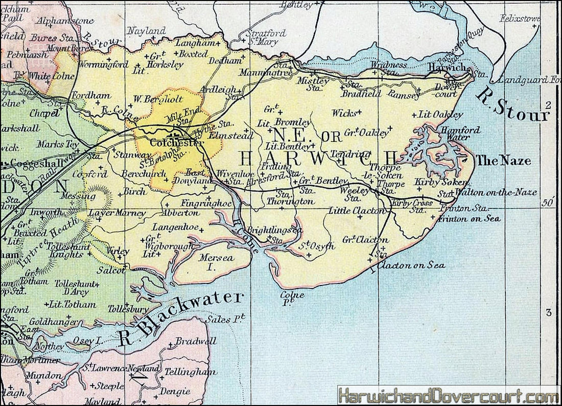
~ 1835 ~ Essex Colchester Maldon Harwich H&D ~

Colchester Maldon and Harwich Essex parliamentary boundaries antique map featuring three Essex constituencies.
Original outline hand-coloured antique engraving from Samuel Lewis’s Topographical Dictionary of England.
Samuel Lewis (c.1782 – 1865.)
Published 1835.
Image size approx. 7×9.5ins
Original outline hand-coloured antique engraving from Samuel Lewis’s Topographical Dictionary of England.
Samuel Lewis (c.1782 – 1865.)
Published 1835.
Image size approx. 7×9.5ins
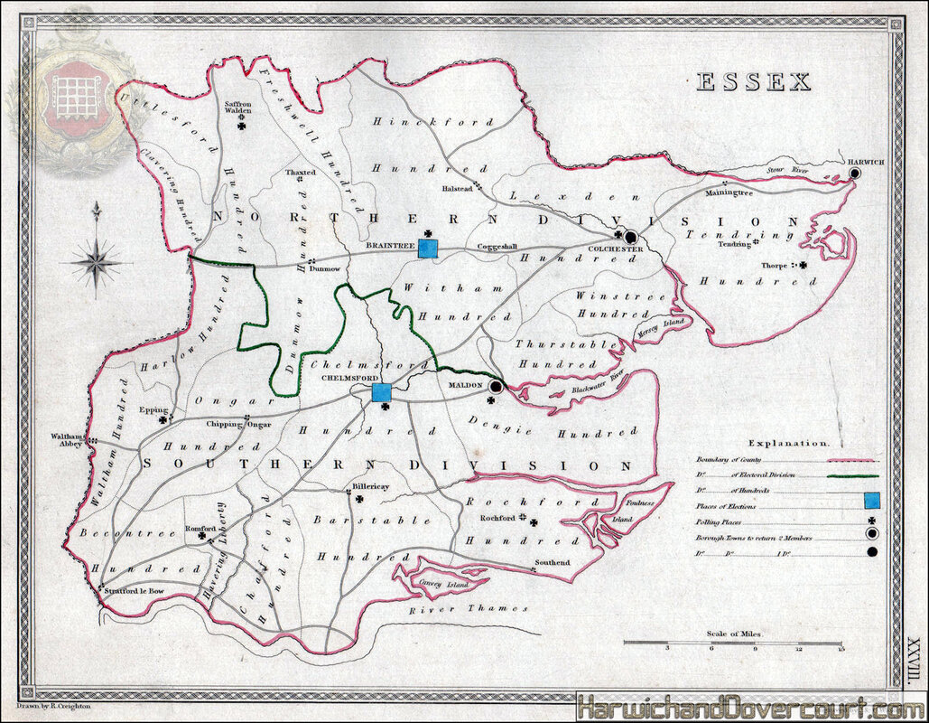
~ 1835 ~ Essex Parliamentary Boundaries H&D ~
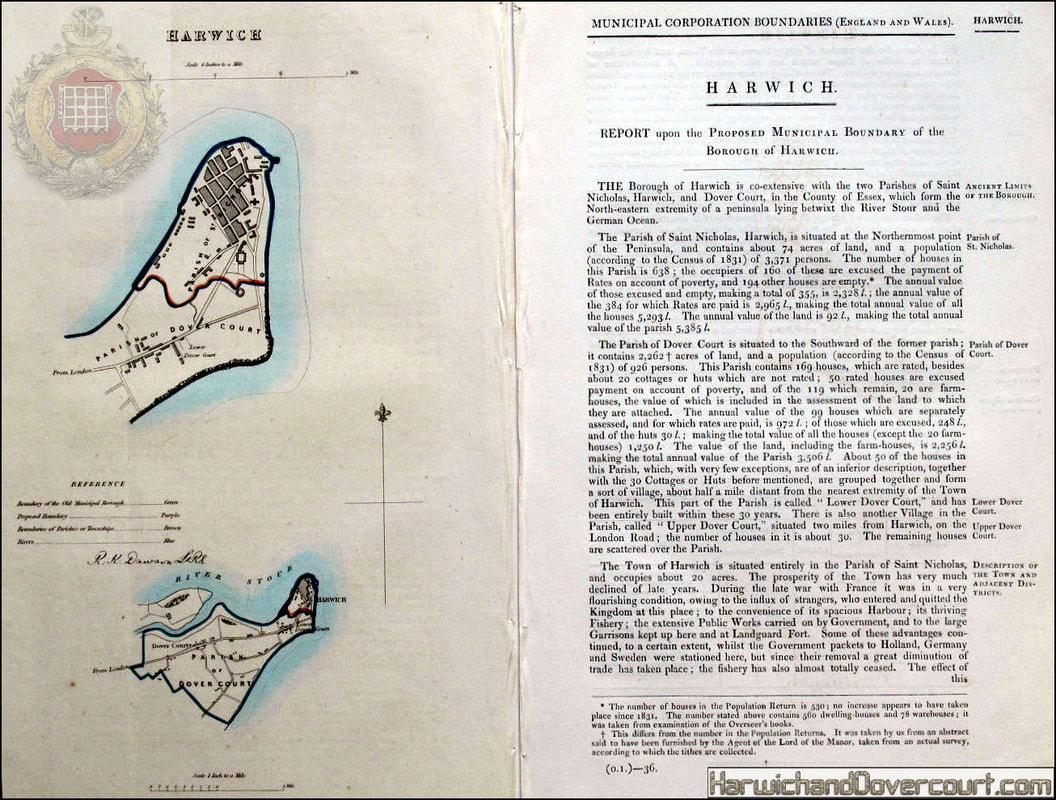
~ 1837 ~ Harwich Town Plan by Dawson H&D ~

Harwich borough/town plan.
Boundary Commission. Essex. Dawson 1837 old map
'Harwich' by Robert K. Dawson Lieut. R.E. (1837). Antique lithographic map with original hand colour, 30.5 x 18.0cm, 12 x 7.25 inches
The map was published a few years after the 1832 Reform Act, within the 1837 Boundary Commission report to the House of Commons. Most of these maps shows the existing municipal borough boundaries in green, the parliamentary boroughs (if different) in red, and the proposed boundary in purple. The boundaries were used to determine the parliamentary consituencies at the time.
"Reports of the Commissioners appointed to report and advise upon the Boundaries and Wards of certain Boroughs and Corporate Towns in England and Wales. Part I." Presented by His Majesty's command /060117/ [Reform Act boundary report]
~ 1837 ~ Harwich Town Plan by Dawson II H&D ~
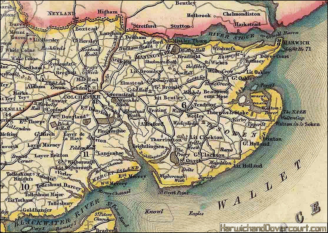
~ 1840 ~ Isaac Slater Map of Essex H&D ~
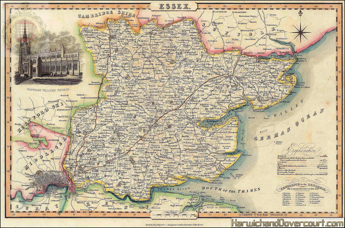
1840 Isaac Slater, 1840 c.
Essex
Attractive Victorian map of Essex, including London, with inset vignette of Saffron Walden Church.
Original hand colour.
Essex
Attractive Victorian map of Essex, including London, with inset vignette of Saffron Walden Church.
Original hand colour.
~ 1840 ~ Isaac Slater Map of Essex H&D ~
~ A detailed section from N.E. Essex ~
~ 1840 ~ Samuel Lewis Map of Essex H&D ~
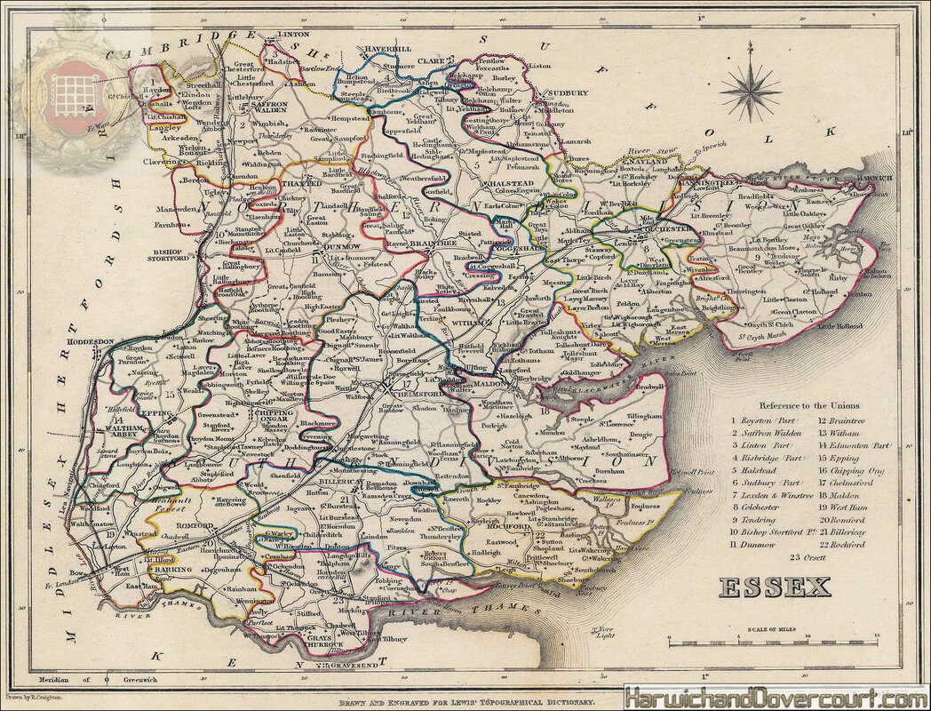
1840 Samuel Lewis
Essex
19th Century county map of Essex with key and reference to the Unions (administrative divisions).
Larger settlements, roads and trainlines are noted, although not to Harwich at this point (work on the Harwich line started in 1844).
Original hand colour.
Essex
19th Century county map of Essex with key and reference to the Unions (administrative divisions).
Larger settlements, roads and trainlines are noted, although not to Harwich at this point (work on the Harwich line started in 1844).
Original hand colour.
~ 1840 ~ Thomas Moule Map of Essex H&D ~
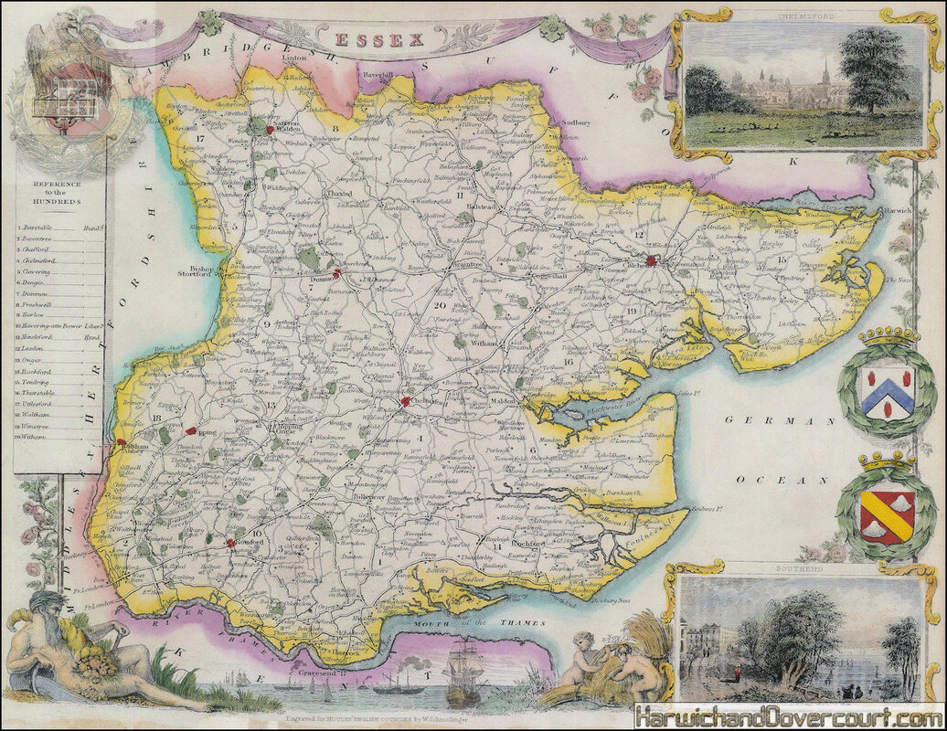
1840 Thomas Moule
Essex
Embellished county map of Essex surrounded by vignettes of local vistas from Gravesend, Chelmsford and Southend.
Coloured.
Essex
Embellished county map of Essex surrounded by vignettes of local vistas from Gravesend, Chelmsford and Southend.
Coloured.
~ 1840 ~ Thomas Moule Map of Essex H&D ~
~ A detailed section from N.E. Essex ~
~ 1845 ~ Dugdale Essex Map H&D ~
~ 1845 ~ Pigots Map Of Essex H&D ~
~ 1845 ~ Pigots Map Of Essex H&D ~
~ A detailed section from N.E. Essex ~
~ 1846 ~ Harwich Railway & Pier From Eastern Union Railway ~ Joseph Locke H&D ~

~ 1850 ~ Henry George-Collins Essex County Map H&D ~
1850 Henry George Collins
Essex
Essex. An attractive Victorian map of the county with focus on its railways and roads.
The Harwich line from Manningtree is now included.
Essex
Essex. An attractive Victorian map of the county with focus on its railways and roads.
The Harwich line from Manningtree is now included.
~ 1865 ~ Ports & Harbours on the East Coast of England H&D ~
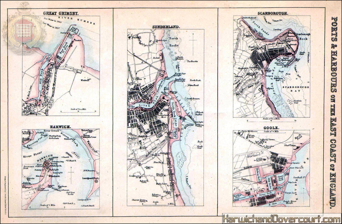
ENGLAND EAST COAST PORTS. Grimsby Harwich Sunderland Scarborough Goole 1865 map
~ 1865 ~ Ports & Harbours on the East Coast of England H&D ~
~ A detailed section from Harwich Town ~

~ 1868 ~ Harwich Proposed Parliamentary Boundary H&D ~

Harwich, Essex. JAMES. Parliamentary Boundary Commission
Harwich, Essex. JAMES. Parliamentary Boundary Commission 1868 old antique map
'Harwich' by Henry James (1868). Antique colour Parliamentary boundary revision map, 34.5 x 23.5cm, 13.5 x 9.25 inches
"Report of the Boundary Commissioners for England and Wales", 1868. printed by George Edward Eyre & William Spottiswoode, for Her Majesty's Stationery Office, London
~ 1868 ~ Harwich Proposed Parliamentary Boundary H&D ~
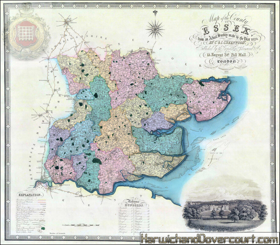
~ 1886 ~ George W Bacon Essex Map H&D ~
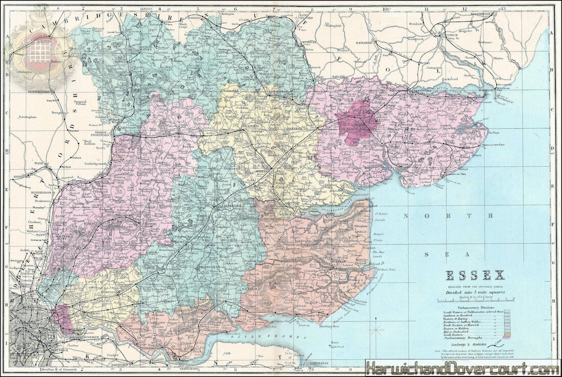
1886 George W. Bacon
Essex
A county map of Essex, including parts of what are now Greater London, such as Stratford, Walthamstow, and Barking.
Parliamentary divisions are noted and railways are marked.
Printed colour.
Essex
A county map of Essex, including parts of what are now Greater London, such as Stratford, Walthamstow, and Barking.
Parliamentary divisions are noted and railways are marked.
Printed colour.
~ 1886 ~ George W Bacon Essex Map H&D ~
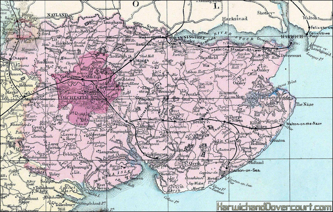
~ 1895 ~ George Philip & Son The County of Essex H&D ~
~ A detailed section from N.E. Essex ~
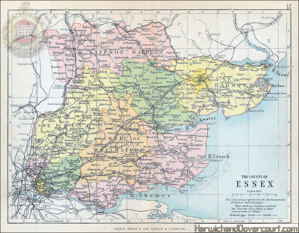
1895 George Philip & Son Ltd.
The County of Essex
Detailed atlas map of the county of Essex and the mouth of the River Thames, marking roads, canals and railways.
Printed colour.
The County of Essex
Detailed atlas map of the county of Essex and the mouth of the River Thames, marking roads, canals and railways.
Printed colour.
~ 1895 ~ George Philip & Son The County of Essex H&D ~
~ A detailed section from N.E. Essex ~
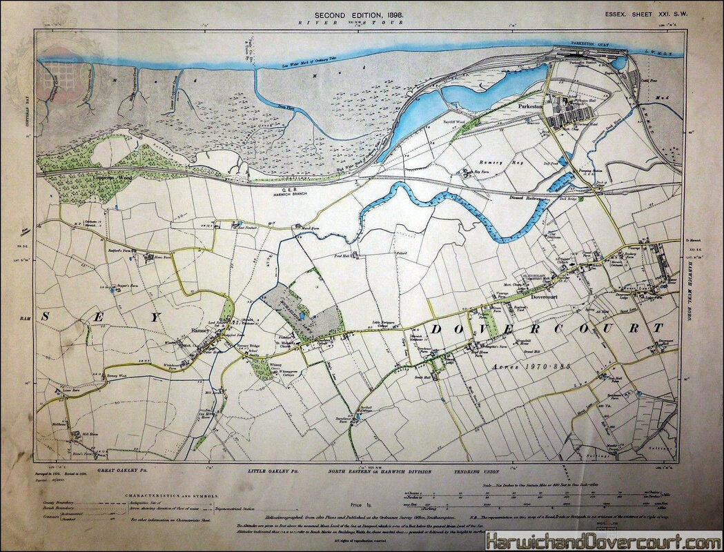
~ 1898 ~ River Stour ~ Second Edition ~ Essex Sheet ~ XXI ~
Picture 044
Picture 045
Picture 046
