~ Essex & Suffolk ~ Sea Charts, Town Plans & Maps ~
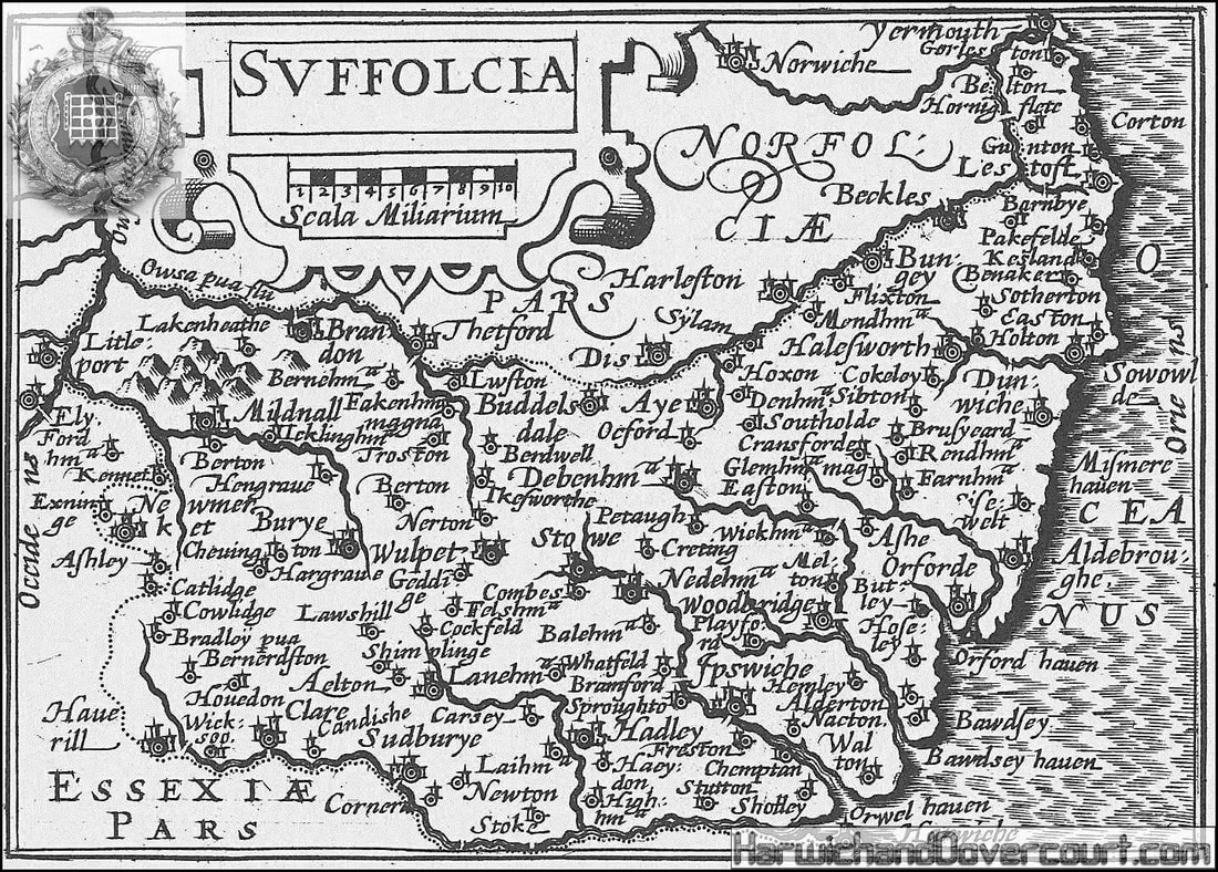
~ 1603 ~ Suffolk by Van Den Keere H&D ~
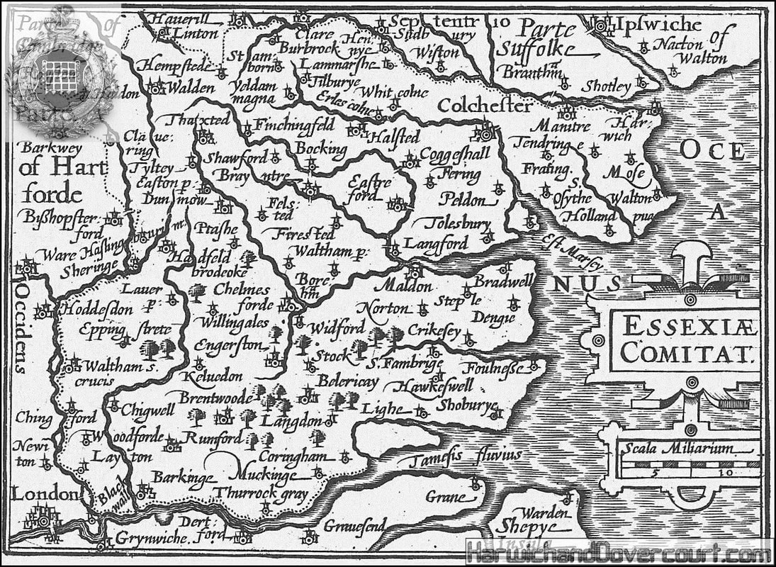
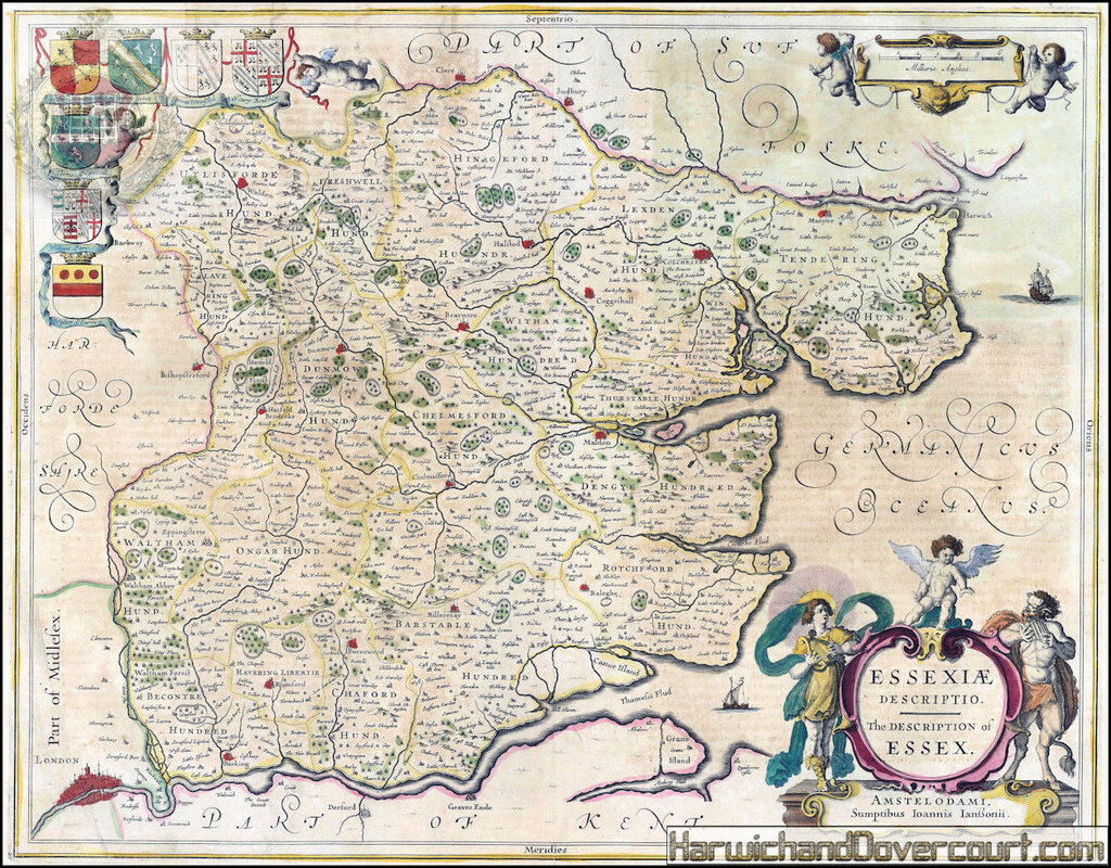
~ 1603 ~ Essex by Van Den Keere H&D ~
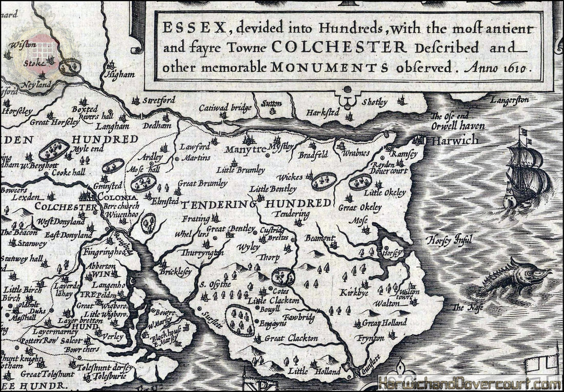
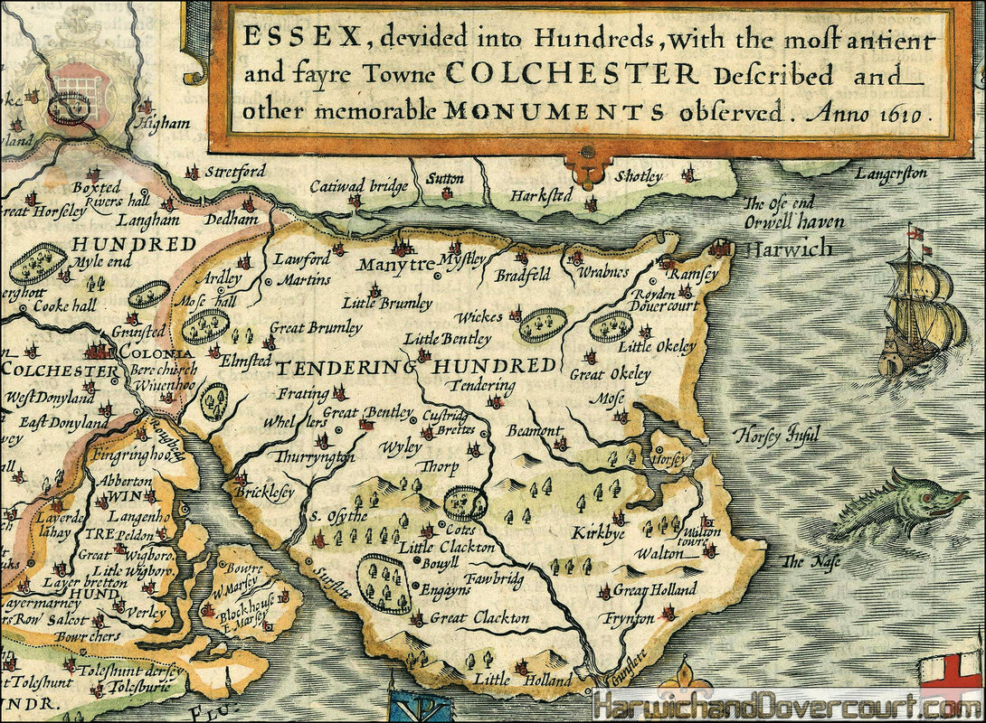
~ 1610 ~ Essex by John Speed H&D ~
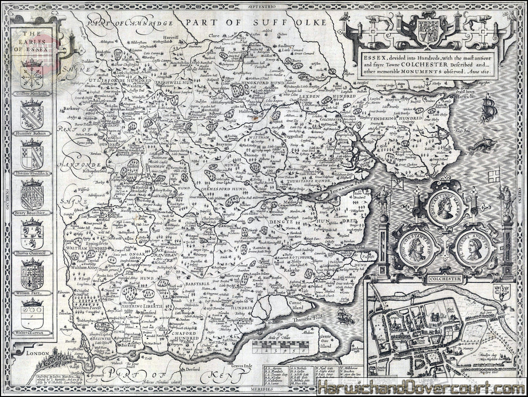
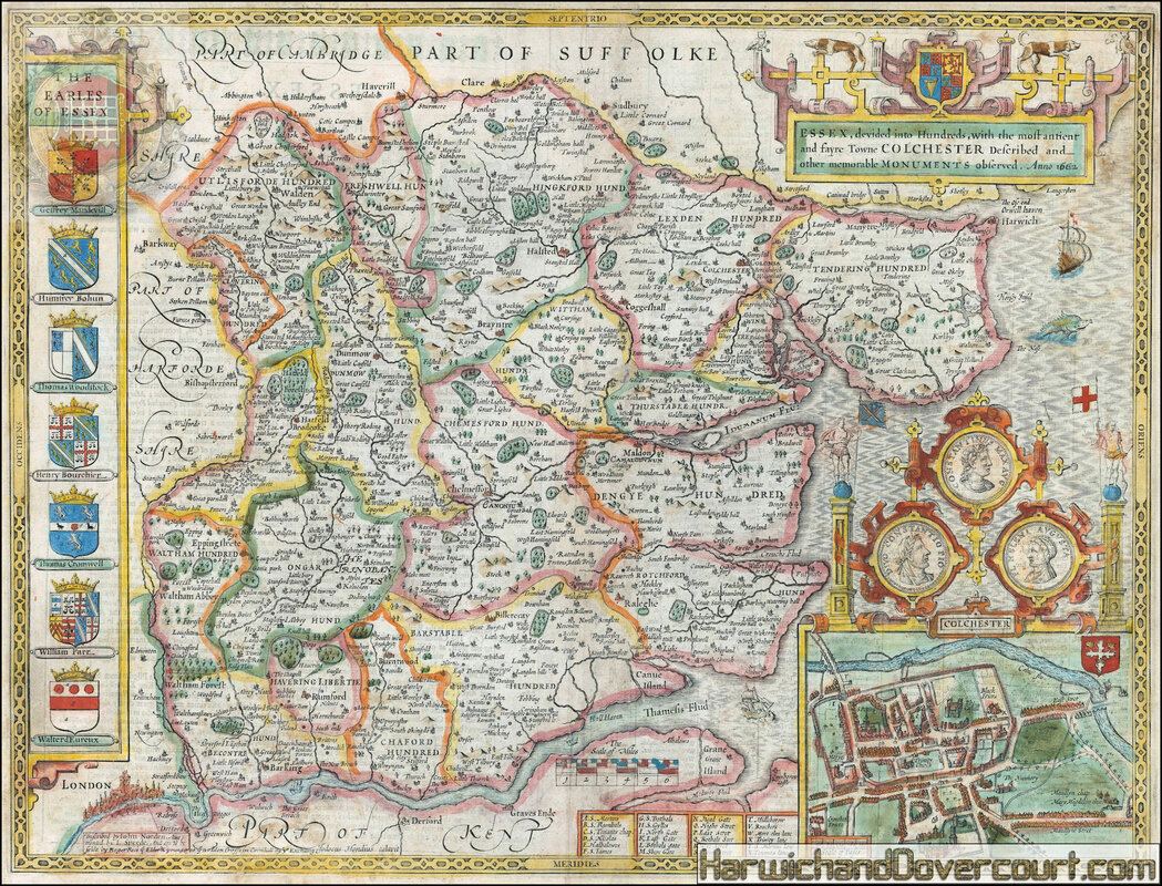
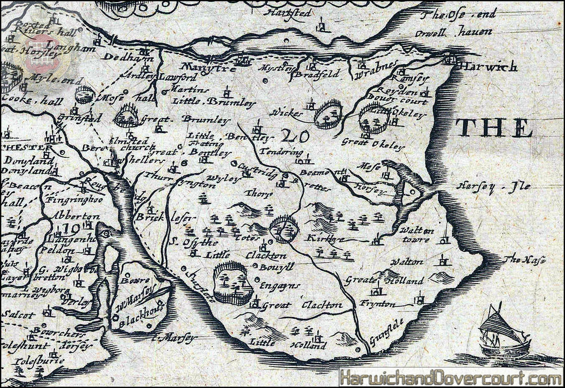
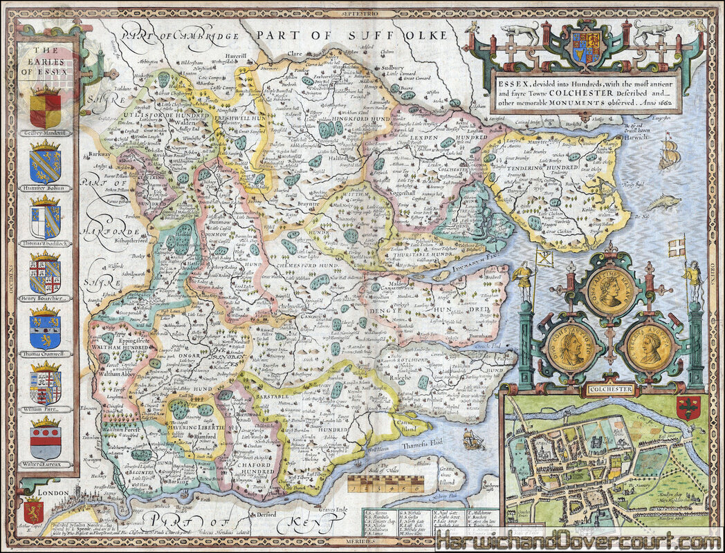
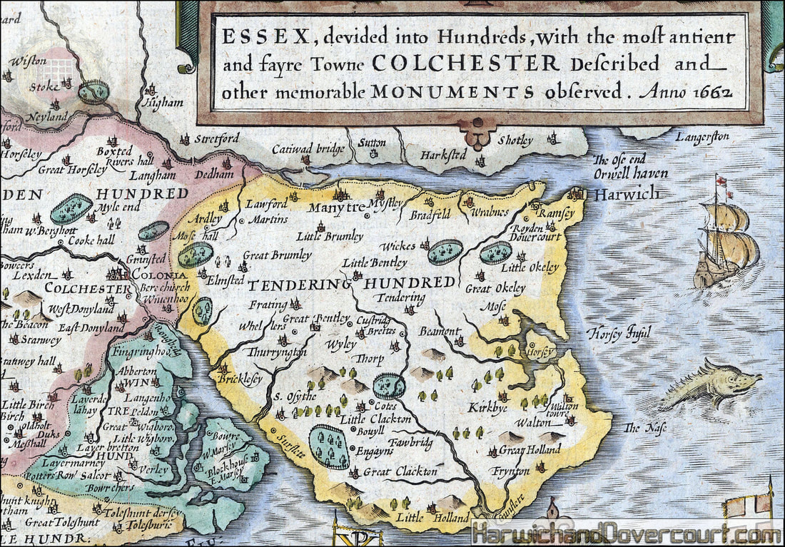
Essex, divided into its Hundreds, with the most antient and fayre Towne Colchester Described, alongside other memorable Monuments observed
Essex. An extraordinary map of the county from the second edition of Speed's seminal atlas, 'The Theatre of Great Britaine'. Vignette of Colchester.
Essex. An extraordinary map of the county from the second edition of Speed's seminal atlas, 'The Theatre of Great Britaine'. Vignette of Colchester.
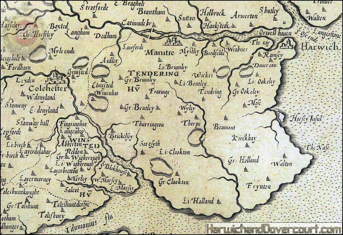
~ 1610 ~ Essex by John Speed H&D ~ N.E. Detailed ~
~ 1620 ~ South East England, The Home Counties H&D ~ Detailed ~
~ 1620 ~ South East England, The Home Counties H&D ~
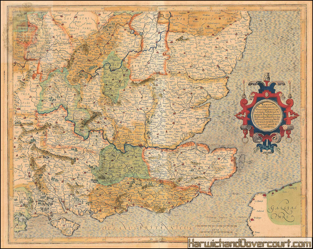
Southeast England & the Home Counties
South East of England, from Leicestershire, Gloucestershire, Wiltshire and Hampshire across to Suffolk, Essex and Sussex. With decorative cartouche and 'silk sea'.
South East of England, from Leicestershire, Gloucestershire, Wiltshire and Hampshire across to Suffolk, Essex and Sussex. With decorative cartouche and 'silk sea'.
~ 1627 ~ Speeds Map Of Essex H&D ~
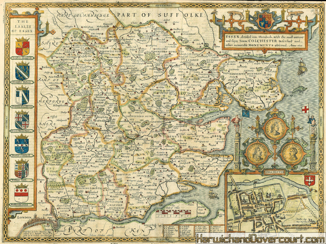
Essex devided into Hundreds, with the most antient and fayre Towne Colchester. Described and other memorable Monuments observed. Anno 1610.
Publisher
Described by Iohn Norden, augmented by I. Speede, And are to be solde by G. Humble, Engraved map with hand colouring.
A map of Essex, with an inset map of Colchester, and reproductions of three Roman coins or medallions showing Constantine the Great in his dual role as chief priest and emperor, and his mother Saint Helena. Saint Helena is the patron saint of Colchester; some British medieval sources claimed she was British, and that Constantine was born in the city. Colchester's coat of arms, shown at the upper right corner of the inset map, show the relics of the True Cross and the crowns of the Magi which she supposedly found in Jerusalem.
John Speed (1552-1629) was the outstanding cartographer of his age. His 'Theatre of Great Britain' was the first atlas of the British Isles: Speed prepared the maps himself about two years before they were published. His maps and books dominated the seventeenth-century English market. The present map is taken from the 1627 English edition published by George Humble.
~ 1627 ~ Speeds Map Of Essex H&D ~ N.E. Detailed ~
~ 1632 ~ Speed Map of Essex H&D ~
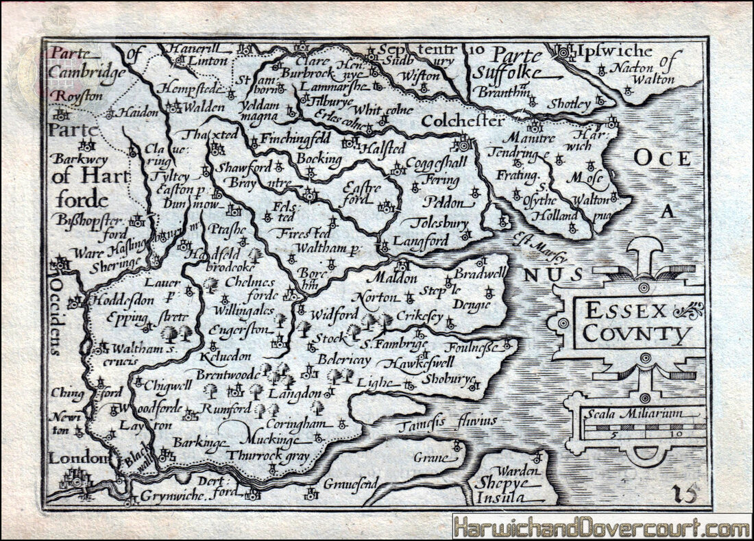
Essex County by van den Keere. "Speed miniature" county map from 1632
Antique "Speed miniature" county map; Pieter van den Keere [Petrus Kaerius]. The maps are known as "Speed miniatures" as they were published alongside Speed's "Theatre of Great Britain" by the same publisher, however most of the maps are printed from plates engraved by Van den Keere. Speed's involvement in the publication of these maps is thought to have been limited (1632 [Undated, but this is edition B as described by Skelton, who conjectures that it was issued with the 1632 folio edition of the same year of Speed's Theatre]). 9.5 x 13.5cm, 3.75 x 5.25 inches.
These maps, most of which are by Pieter van den Keere, are known as "Speed miniatures" because they were published in pocket versions of, coincident with some editions of, and containing much common content with Speed's own atlases, by Speed's own publishers; and the title page states the miniature version to be "from a farr Larger Voulume Done by John Speed". Although often attributed to John Speed, it is believed that Speed's actual involvement was limited at best.
~ 1637 ~ Essex by Christopher Saxton & William Kip H&D ~ N.E. Detailed ~
~ 1637 ~ Essex by Christopher Saxton & William Kip H&D ~

Christopher Saxton & William Kip , 1637
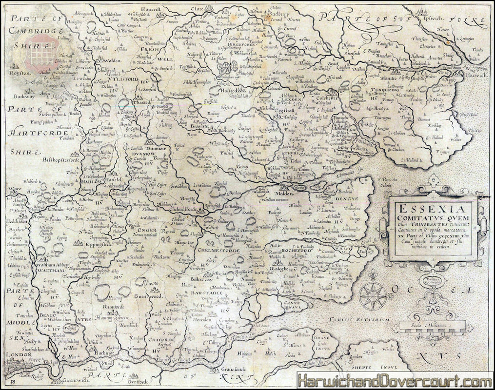
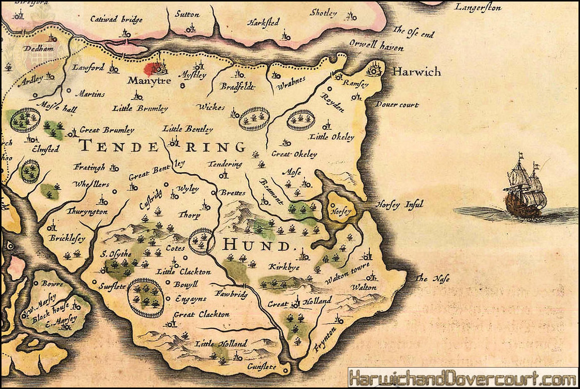
The third available map of the county of Essex, probably based on Christopher Saxton's map of 1579, but here reduced by William Kip for Camden’s 1637 edition of the “Britannia.”
William Camden first published his venerable geo-historical compendium of Great Britain and Ireland, “Britannia” in 1586 and it proved extremely popular. By 1589, encouraged by the success of Christopher Saxton’s atlas, Camden began preparations to illustrate his work with a set of county maps. Despite this lengthy lead time, the first time the work contained a set of county maps was in the 1607 sixth edition of the work. The maps injected a new lease of life into the publication and it became such a library staple that further editions were issued into the early 19th century, albeit with different maps.
The Saxton Kip or Saxton Hole maps, as they are generally known, provide an almost unique opportunity for the collector to acquire either the first available or second available map of a particular English county. These maps were only present in the sixth, seventh and eighth edition of the Britannia published 1607, 1610 and 1637 before the maps were revised and updated by other cartographers. They were usually issued in black and white but on very rare occasions, bespoke colouring was added at the time of publishing. This is one of the maps in the Britannia which does not cite a source although Kip is still noted as the engraver. Saxton did produce a map of Essex 1579 and there it was also one of the maps which were part of the mysterious incomplete set of twelve county maps which for centuries were attributed only as “Anonymous” but are now attributed to William Smith. The first state of the Smith maps of 1602-3 are not commercially available but later editions from the mid-17th century occasionally appear on the market. It is possible that Camden used a combination of both the Smith and Saxton maps as a source, hence his reluctance to cite just Saxton as his source.
This example here is from the 1637 edition and is distinguished by the addition of beautiful original colour contemporaneous to time of publishing.
~ 1637 ~ Essex by William Kip H&D ~
~ 1637 ~ Essex by William Kip H&D ~ N.E. Detailed ~
~ 1647 ~ Essex by Jan Jansson H&D ~
~ Jan Jansson , 1647 c. ~ Essexiae Descriptio : The Description of Essex ~ 16 x 20 in ~
Grand Dutch Golden Age map of Essex with coats of arms and elaborate cartouche.
[Skelton, R. A.: "County Atlases of the British Isles 1579-1703": 40] Coloured.
Grand Dutch Golden Age map of Essex with coats of arms and elaborate cartouche.
[Skelton, R. A.: "County Atlases of the British Isles 1579-1703": 40] Coloured.
~ 1647 ~ Essex by Jan Jansson H&D ~ N.E. Essex ~
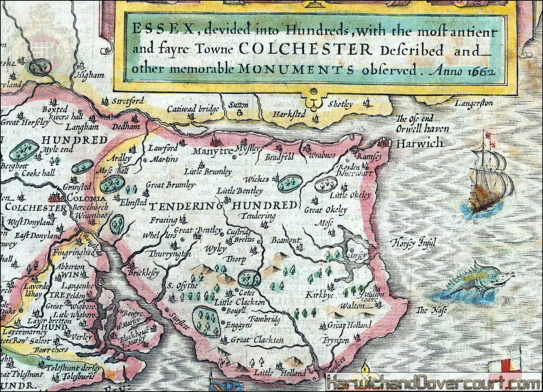
~ 1662 ~ Essex by Rodger Rea H&D ~
Essex, devided into Hundreds, with the most antient and fayre Towne Colchester
Described and other memorable Monuments observed.
Publisher
To be solde by Roger Rea ye elder & younger at ye Golden Crosse in Cornhill agt. ye Exchang.
A Double-page engraved map, fine contemporary outline hand colour, upper left and right margins skilfully repaired,
margins reinforced with japan paper.
The map bears the imprint of Roger Rea the Elder and Younger. The Reas had purchased the rights to Speed's work from William Garrett in 1659, who had previously purchased them from the widow of William Humble in the same year. Skelton suggests that the father and son intended a new edition of the atlas for the Restoration of 1660. However, the atlas would appear not to have been published until 1665. This is borne out by an advertisement in the Term Catalogue by the subsequent owners of the plates, Thomas Bassett and Richard Chiswell, in 1675:
"Mr John Speed's... Geography of the Kingdoms of England, Scotland, and Ireland... together with his Prospect... all in one entire Volume, hath been, for seven Years past, out of Print, the greatest part of an Impression, then newly Printed, being destroyed by the late dreadful Fire, 1666". This is borne out by the rarity of the Rea edition of the atlas. There is evidence that they planned an edition of 1666, as there are impressions of Sussex, Buckingham and Derby, with Rea's imprint, which bear that date. Rea would later sell the plates to Bassett and Chiswell, who would publish a new edition in 1676.
~ 1662 ~ Essex by Rodger Rea H&D ~ N.E. Detailed ~
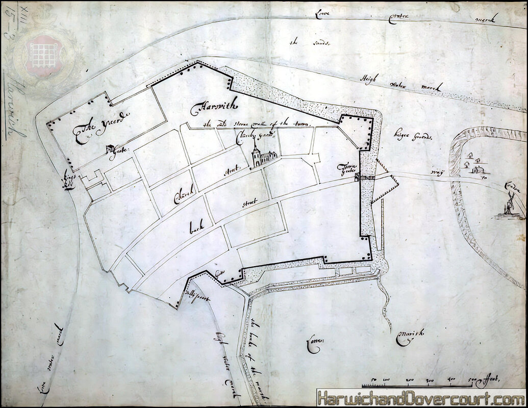
~ 1669 ~ Plan of the Harwich Defences H&D ~
Plan of Harwich defences
Single sheet. Col. ms. Medium: Mounted on backing sheet. Scale: [ca. 1:2 580].Cartographic Note: North at 78 degrees. Scales in feet and yards. Additional Places:Medway. Contents Note: High and low water lines and sounding shown. Note onsoundings. Ships depicted at anchor. Inset profi les of the fortifi cations.
Single sheet. Col. ms. Medium: Mounted on backing sheet. Scale: [ca. 1:2 580].Cartographic Note: North at 78 degrees. Scales in feet and yards. Additional Places:Medway. Contents Note: High and low water lines and sounding shown. Note onsoundings. Ships depicted at anchor. Inset profi les of the fortifi cations.
~ 1673 ~ A Mapp of ye County of Essex by Richard Blome H&D ~
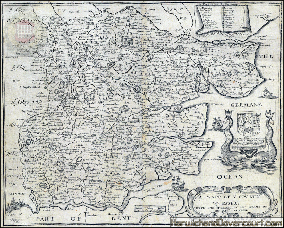
A Mapp of ye County of Essex
Attractive and rare map of Essex divided into Hundreds and embellished with ships. The dedication is particularly attractive, being supported by two large sea monsters.
Attractive and rare map of Essex divided into Hundreds and embellished with ships. The dedication is particularly attractive, being supported by two large sea monsters.
~ 1673 ~ A Mapp of ye County of Essex by Richard Blome H&D ~ N.E. Detailed ~
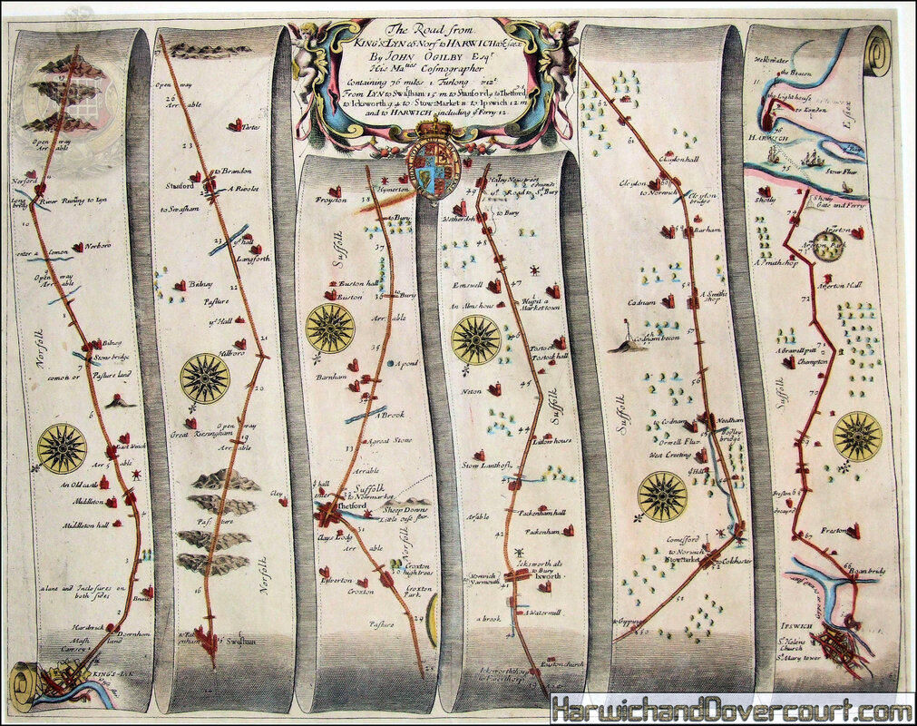
~ 1675 ~ Kings Lyn to Harwich, Essex Map by John Ogilby H&D ~
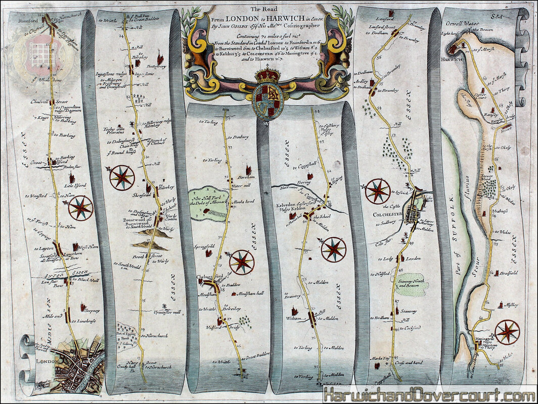
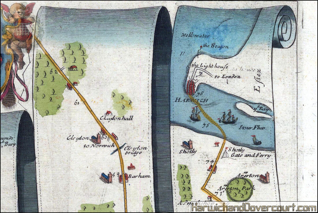
~ 1675 ~ London to Harwich, Essex Map by John Ogilby II H&D ~
~ 1676 ~ Essex by John Speed H&D ~
Essex, devided into Hundreds, with the most antient and fayre Towne Colchester
Described and other memorable Monuments observed. Anno 1662.
Double-page engraved map with hand colour.
Publisher
And are to be solde by Tho: Bassett in Fleet Street, and Ric: Chiswell in St. Pauls Churchyard, London
A map of Essex from the 1676 edition of the first large-scale atlas of the British Isles, Speed's 'Theatre'. In the bottom right-hand corner is an inset town-plan of Colchester, with points of interest including 'S. Rumbals' and 'Cowe Stret' marked using an alphabetical key. Above this are portrait medallions of the Roman Emperor Constantine, his father Constantius, and his mother Helena. Helena is the patron saint of Colchester, reported by Geoffrey of Monmouth to be the daughter of its legendary founder, King Coel. Accompanying text in English, 'Hundreds in Essex' and 'The Description of Essex' is printed on the verso.
John Speed (1552-1629) was the outstanding cartographer of his age. By trade a merchant tailor, but by proclivity a historian, it was the patronage of Sir Fulke Greville, poet and statesman, that allowed him to pursue this interest in earnest. His 'Theatre of Great Britain', from which the present work is drawn, was first published in 1611 or 1612 and is 'the earliest English attempt at atlas-production on a grand scale' (Skelton). Drawing heavily on the work of
Saxton and Norden, little of Speed's cartography is original (he acknowledges, 'I have put my sickle into other mens corne'), instead it is his blend of cartography and history, incorporating town-plans, vignettes, and genealogy, that makes Speed an innovator.
This map is from the 1676 edition of the 'Theatre', published by Thomas Bassett and Richard Chiswell.
~ 1676 ~ Essex by John Speed H&D ~ N.E. Detailed ~
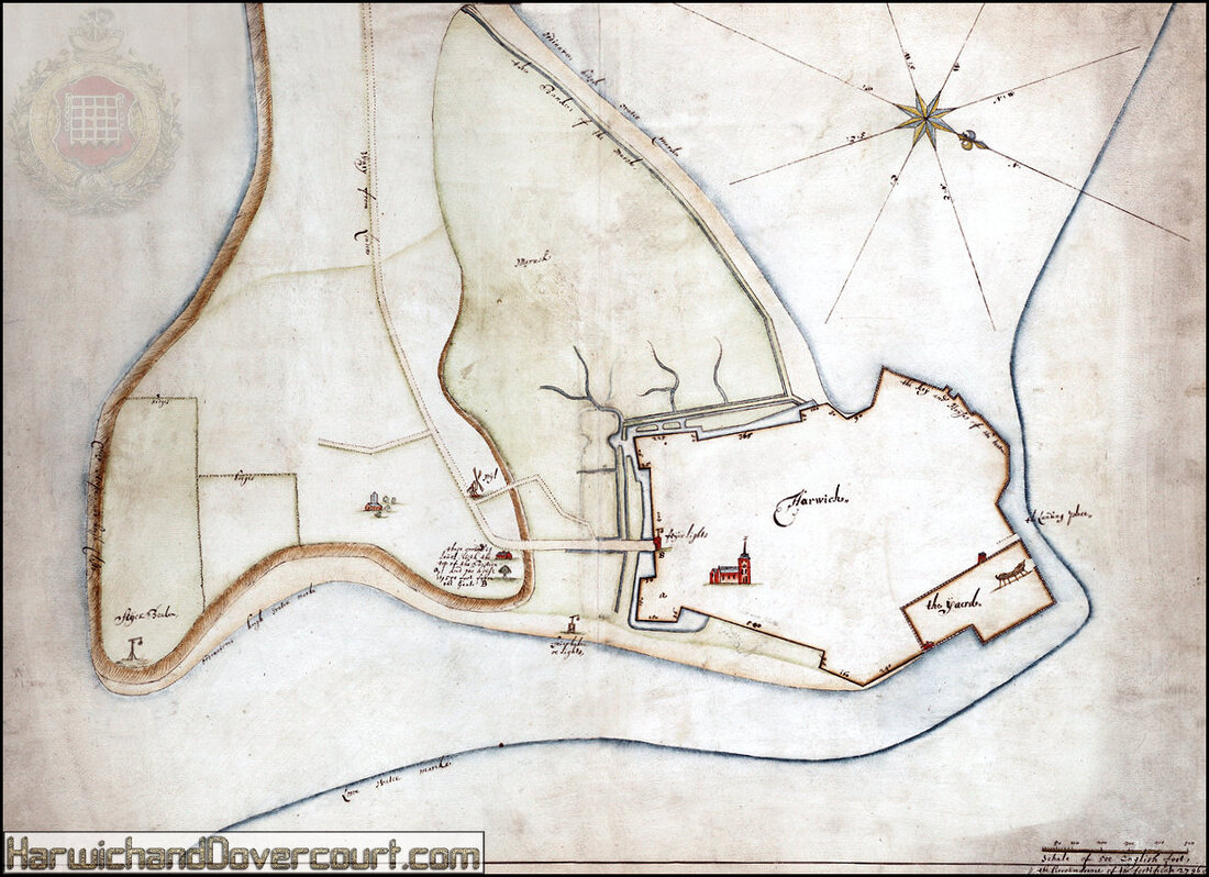
~ 1680 ~ Sir Bernade De Gomme ~ Harwich Towne ~ H&D ~

The first permanent fort on Landguard Point, one of the few early Stuart forts in England, was built in 1625–30 to protect Harwich Haven, in response to a renewed Franco-Spanish threat. It was a low, bastioned fort of shingle revetted with turf and timber, shielding brick buildings. In the 1660s, Harwich was refortified to the designs of the engineer Sir Bernard de Gomme, with Landguard repaired and strengthened by a brick wall. In July 1667 its garrison repulsed an attack by 1,500 Dutch marines and a powerful squadron of warships.
Plans for extended defences are revealed in a drawing for an outwork across the peninsula, in de Gomme's hand, and repairs in the 1680s included two curtain walls. A survey in 1708 reported that Landguard was too small and its confined site precluded outworks. In 1716 Lt John Brookes recommended its replacement in response to the Jacobite threat. The fort was demolished in 1717 and a new one built by 1720.
Plans for extended defences are revealed in a drawing for an outwork across the peninsula, in de Gomme's hand, and repairs in the 1680s included two curtain walls. A survey in 1708 reported that Landguard was too small and its confined site precluded outworks. In 1716 Lt John Brookes recommended its replacement in response to the Jacobite threat. The fort was demolished in 1717 and a new one built by 1720.
~ 1680 ~ Sir Bernade De Gomme ~ Harwich Towne ~ Landscape H&D ~
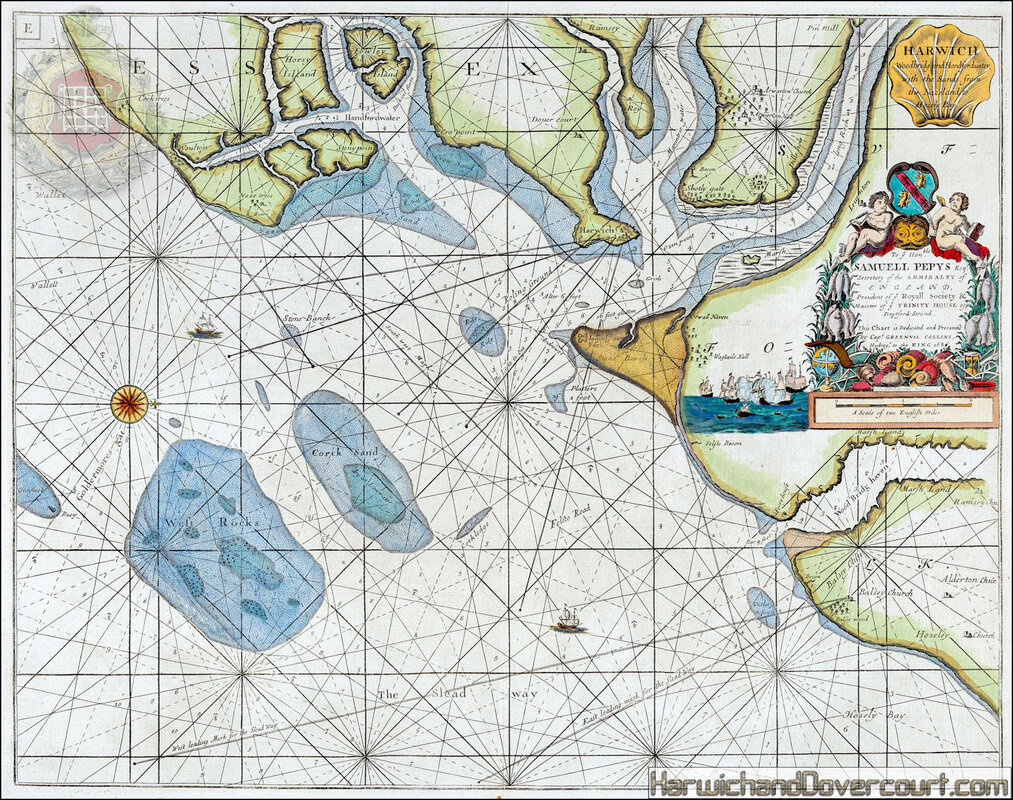
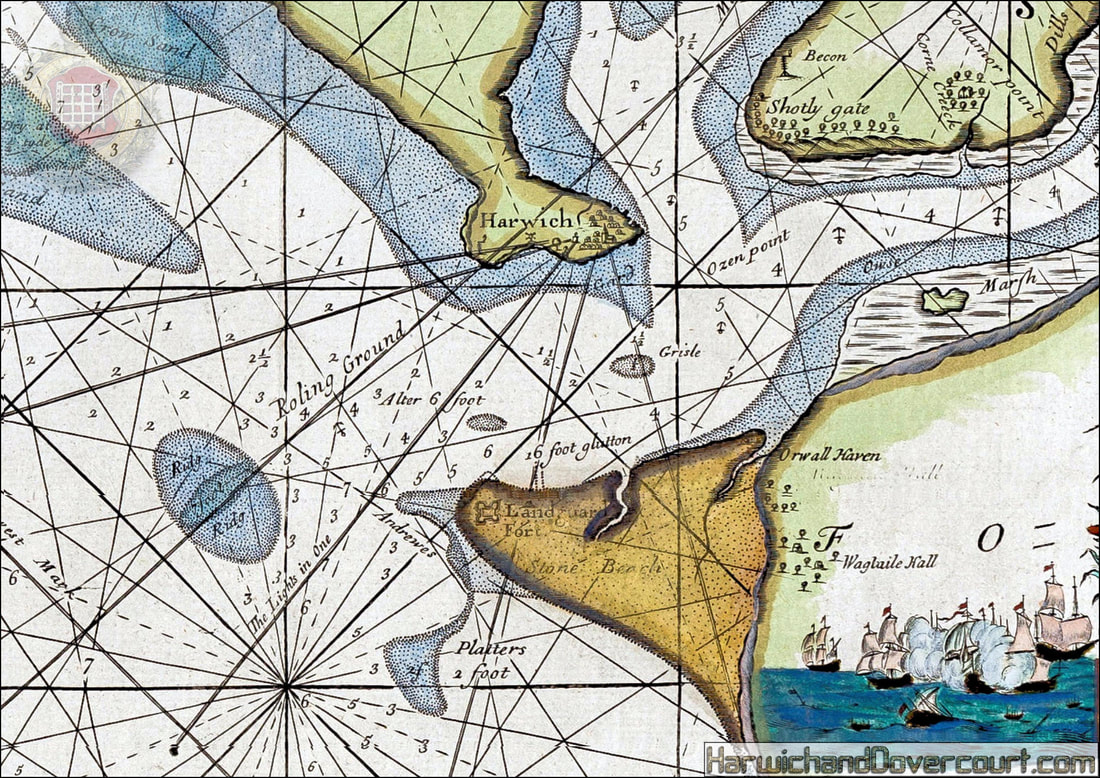
~ 1686 ~ Harwich Chart Samuell Pepys H&D ~
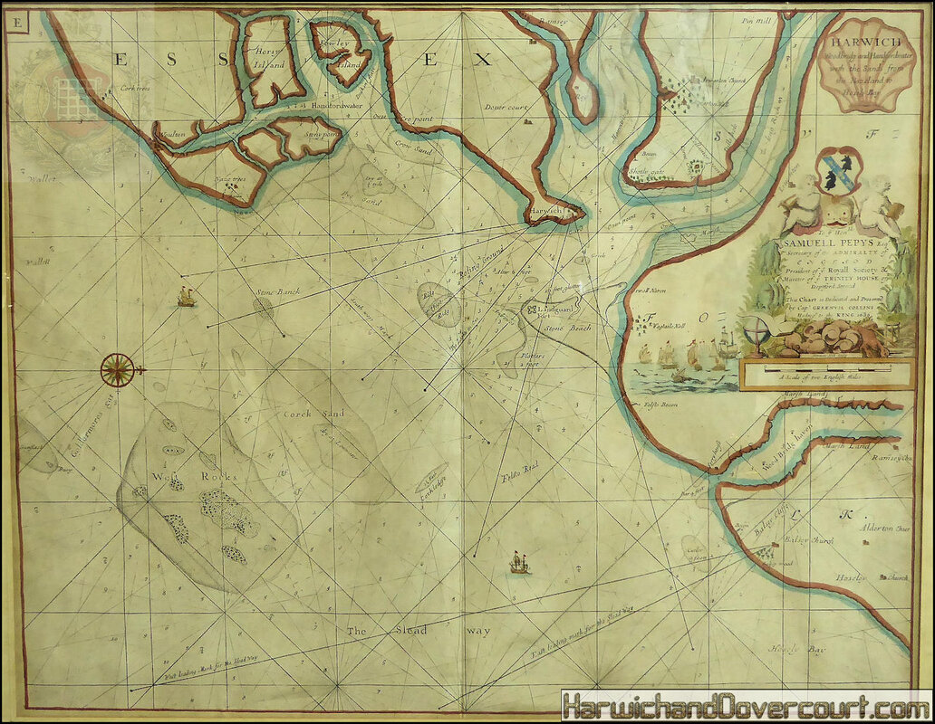
Harwich, Woodbridge and Handfordwater with the sands from the Nazeland to Hosely Bay.
'Harwich, Woodbridge and Handfordwater, with the Sands from the Nazeland and to Hosely Bay - To the Honble. Samuell Pepys Esqr., Secretary of the Admiralty of England, President of ye Royal Society &c Master of ye Trinity House of Deptford-Strond this chart is dedicated and presented by Capt. Greenvil Collins, Hydrogr. To the King 1686'
This nautical chart shows Harwich and the adjacent rivers, sandbanks and coastline between Hollesley and Walton-on-the-Naze, including the estuaries of the Orwell, Stour, Deben ('Woodbridge haven') and Hamford Water. Bawdsey, Hollesley, Harwich, Shotley and Walton are marked, along with Landguard Fort (close to Felixstowe). The chart is orientated towards the west.
DATE PRINTED
1686 (First edition)
IMAGE SIZE:
Approx 46.5 x 59.5cm, 18.25 x 23.25 inches (Large); Please note that this is a folding map.
TYPE
Decorative antique eighteenth century copperplate nautical sea chart, printed on thick paper
ARTIST/CARTOGRAPHER/ENGRAVER:
Captain Greenvile (or Greenville) Collins. Collins was an officer of the Royal Navy and prominent hydrographer, who was commissioned by King Charles II in 1676 and appointed by Samuel Pepys (then Secretary to the Admiralty), to chart the coasts of Great Britain. The resulting atlas - Great Britain's Coasting Pilot - was the first original sea atlas to be produced by an Englishman. Prior to publication of these maps, nautical charts were often defective, and there was no centralised system for collecting and disseminating the better maps made by experienced seamen. In 1681, Collins gained the king's preferment to survey the country's coasts. The Admiralty supplied Collins with the 8-gun yacht HMS Merlin for the first two years and later the yacht HMS Monmouth until 1686. His work was carried out under the supervision of Trinity House, who also supported the project financially. Samuel Pepys insisted that Collins be made a younger brother of Trinity House. Collins spent seven years on the survey, the first edition of which was published in 1686, as "Great Britain's Coasting Pilot". The charts, while not completely accurate, were an enormous advance on anything before them, entitling Collins to rank as not only one of the earliest, but also among the best of English hydrographers. Twenty-one further editions were published during the eighteenth century.
PROVENANCE
"Great Britain's Coasting Pilot: being a new and exact survey of the sea-coast of England and Scotland from the river of Thames to the westward and northward; with the islands of Scilly and from thence to Carlile...", by Captain Greenvile Collins, Hydrographer in Ordinary to the King and Queen's most Excellent Majesties. London: printed by Freeman Collins, and are to be sold by Richard Mount Bookseller, at the Postern on Tower-Hill, 1686
~ 1686 ~ Harwich Chart Samuell Pepys H&D ~
~ Please be aware that this map has been reproduced many times & modern prints are being sold as "Antique" ~
~ 1686 ~ Harwich Chart Samuell Pepys H&D ~
~ Always ask the seller for verification that you are not being sold a modern reprint if being advertised as "Old" ~
~ 1689 ~ Ogilby and Morgan's Rare Map of Essex H&D ~
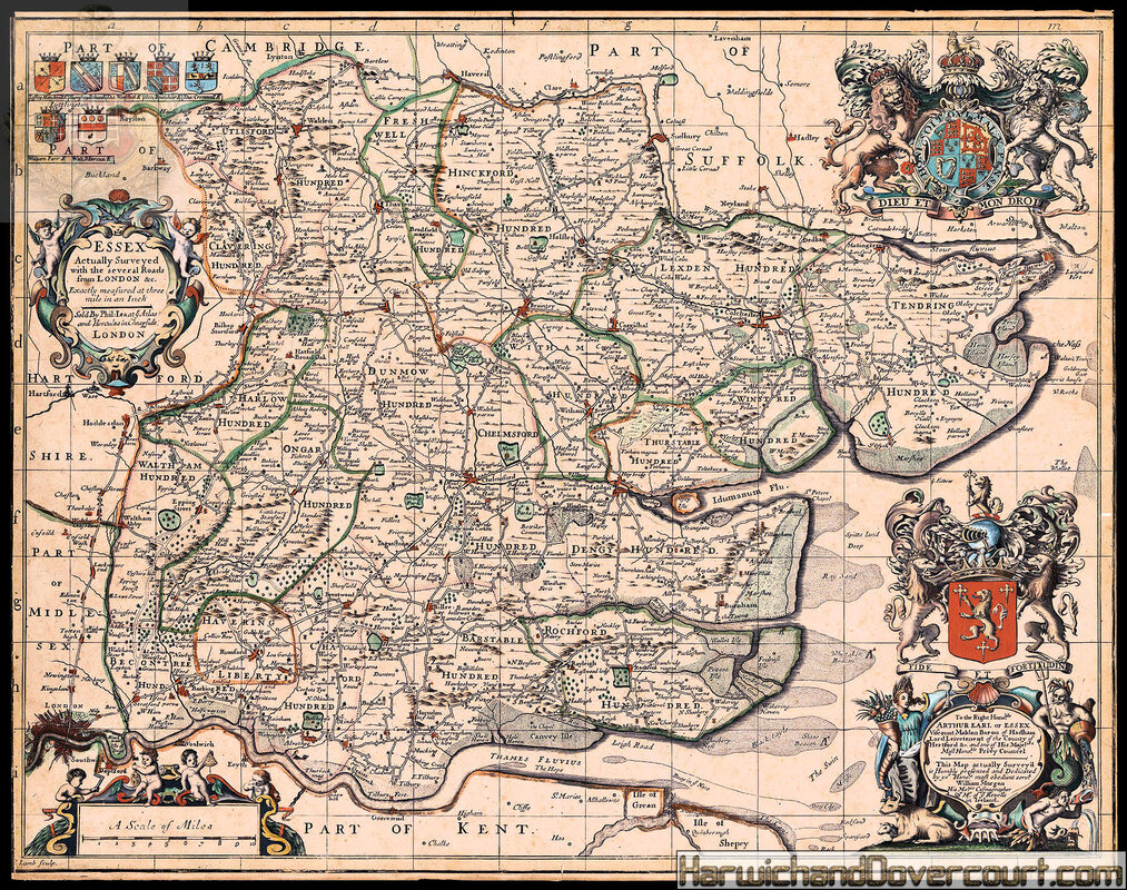
Essex Actually Surveyed with the several Roads from London &c. Exactly measured at three mile in an Inch.
Author
William Morgan and John Ogilby
Publisher
Sold By Phil. Lea at ye Atlas and Hercules in Cheapside,
Publication place
London,
A new state of the map by John Ogilby and William Morgan (first published in 1678), with Ogilby's name and date removed and Lea's imprint inserted, but Morgan's dedication to Arthur, Earl of Essex, retained. By this point the plate had been acquired by Philip Lea who published it in this edition of the Saxton atlas of c. 1689.
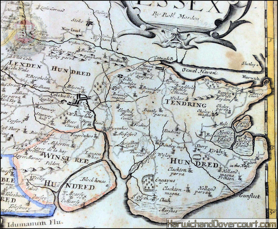
~ 1695 ~ Robert Morden's map of Essex H&D ~
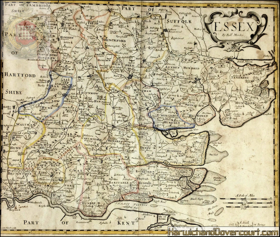
~ 1695 ~ Robert Mordens map of Essex H&D ~ N.E.Detailed ~
~ 1698 ~ John Ogilby - The Road from King's-Lyn to Harwich H&D ~
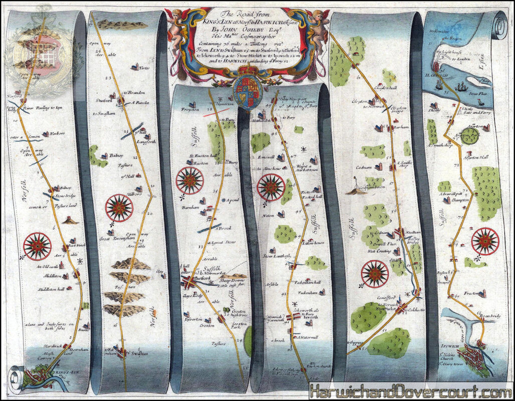
~ 1698 ~ John Ogilby - The Road from King's-Lyn to Harwich H&D~ Detailed ~
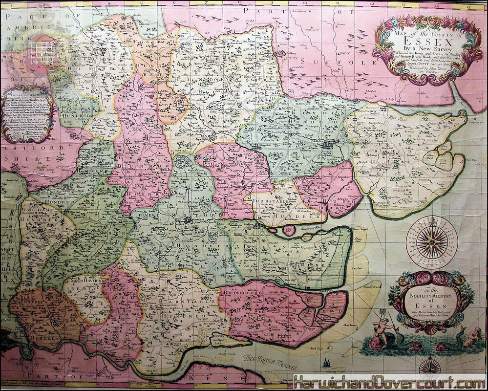
~ 1696 ~ Oliver Map Of Essex ~ H&D ~